 |
Large-scale mining of the Pachnā Hill |
Xuanzang in his pilgrimage to the sacred footsteps of the Buddha in Magadha has mentioned Kapotaka (‘Pigeon’) Monastery. Kapotaka monastery had more than 200 monks following the Sarvāstivāda tradition (Rongxi 1996: 257). The monastery was called so because a bird catcher inspired by the generosity of the Buddha became his follower.
Xuanzang travelled east from Nālandā Saṅghārāma to reach the isolated hill of Indraśailaguhā (refer fig.1). Alexander Cunningham proposed Giriyak Hill (25° 01' 30'' N. 85° 30' 45'' E) as the site of Indraśailaguhā (Cunningham 1873: 145-150). From Indraśailaguhā, Xuanzang travelled 150-160 Li northeast to reach Kapotaka Monastery. Cunningham identified the Buddhist remains of the isolated hill of Pārbati (25° 05' 06'' N. 85° 39' 05'' E) as the Kapotaka (Cunningham 1873: 150-151). More than a half-century later P C Choudhary proposed that Pārbati Hill may be the Indraśailaguhā and not Kapotaka as proposed by Cunningham (Chaudhari 1936: 302). Pārbati Hill is now accepted as the correct identification of Indraśailaguhā.
Kapotaka Monastery according to Xuanzang should be 35-45 km (150-160 Li, One Li = 323 mts) northeast of Indraśailaguhā (i.e., Pārbati Hill). The monastery was situated 2-3 Li north of an isolated hill. Ideally, this lead should be useful in locating Kapotaka. But it isn't for a number of reasons. Firstly, there are many isolated hills and hillocks east/northeast of Pārbati. These hills are collectively called the Sheikhpurā range of hills. Secondly, the Sheikhpurā range of hills is within 25 km of Indraśailaguhā (Pārbati), whereas the isolated hill north of Kapotaka should be 35-45 km. Thirdly, the isolated hill as per Xuanzang was ‘tall and precipitous’ and had beautiful Buddhist shrines. Unfortunately, we have lost a major part of the 12 km-long Sheikhpurā range of hills to large-scale mining.
These hills northeast of Pārbati can be broadly divided into two groups. The first hill range that runs north easterly starts from Kāri Matokhar and ends at Dharampur. The second hill range, the Seikhpurā Hills run from Hasanpur-Makhdampur in the west to Pachnā in the east. Initially, I considered Kāre-Matokhar Hill, 17 km northeast of Pārbati as the possible site of Kapotaka. I explored Kāre and Matokhar in 2011. I did not notice any Buddhist remains in Kāre-Matokhar. Instead, the ancient remains in Kāre-Matokhar suggest the presence of a Brahmanical shrine in the 10th-12th CE. There are a few isolated hillocks east of Pārbati but they are not ‘tall and precipitous’.
Alexander Cunningham (Cunningham 1882: 12-13) and J D Beglar (Beglar, 1878: 116) in their archaeological survey of this region have reported only the Mathokhar Dargāh. In his surveys of the Districts of Gaya and Patna, Francis Buchanan-Hamilton did not mention any ancient sites in and around Sheikhpurā (Buchanan-Hamilton 1925: 81, 87).
An image of the Buddhist deity Vajratārā (11th-12th CE) was exhumed on Pachnā Hill in May 2020 (Directorate of Archaeology 2020). Pachnā Hill (25° 09' N. 85° 54' E) is the eastern end of the Shiekhpurā Range of hills. The discovery of the Buddhist image in Pachnā (Hill) is important because Pachnā is 28 km northeast as the crow flies from Pārwati Hill. Is Pachnā (Hill) the site of the Kapotaka Monastery?
Xuanzang documented, ‘many beautifully constructed temples and shrines with most exquisite carvings and engravings’ on the isolated hill opposite Kapotaka Monastery. The image of Avalokiteśvara in the central temple was mystical in spiritual manifestation. A king of Siṃhala (now Sri Lanka) saw this image of Avalokiteśvara as his reflection in the mirror. He was deeply delighted and, after some effort, he traced the image to this temple in Magadha. He made offerings to the shrine and also constructed one temple. Many kings inspired by the example set by the Siṃhala king developed shrines on this isolated hill. If Pachnā Hill represents the Isolated Hill in question, then it should be laden with remains of the ancient Buddhist shrines.
I visited Pachnā on May 06, 2024. Pachnā is a large village situated south of (Pachnā) hill. Walking through the narrow bylanes of Pachnā I reached the newly constructed Śrī Śrī Vajratārā Siddha Piṭha Mandir on the Hill early in the morning and saw a middle-aged person engaged in the morning cleaning of the temple. He introduced himself as Manish Priyadarshi, the caretaker of the Vajratārā shrine. He removed the covering cloth and allowed me to take pictures of the Vajratārā image. The Vajratārā image is 14.5 inch x 8.4 inch x 0.70 inch in dimension. The image has a dedicatory inscription of a female donor whose name translates. as sinless or faultless (Tribedy 2021: 712). This Vajratārā image is the same artefact that was exhumed in May 2020 while excavating for the column footing of the Pahāḍī Bābā temple. Pahāḍī Bābā temple which is still under construction houses a black stone circular artefact known as ‘Pawan Chakki’ (wind-operated millstone). The Pawan Chakkī artefact is 54 inches in diameter looking like a yoni base of Shiva Linga from 11th-12th CE (Directorate of Archaeology 2020). People also refer to ‘Pawan Chakki’ as ‘Chainaian kā Jātā’ (hand-operated millstone of Chainaian).
As per Manoj ji, the Vajratārā image was buried five to six inches below the surface. I noticed the foundation column of the Pahāḍī Bābā temple (i.e., the findspot of Vajratārā) was a rocky surface. It was apparent that the rocky surface could not be the original place of the Vajratārā image. Dr Harsha Ranjan, Senior Technical Assistant, Directorate of Archaeology was the first archaeologist to visit Pachnā following the newsbreak of the discovery of Vajratārā. Dr Harsh believes that the Vajratārā image was most likely planted at the findspot. There are no remains of any ancient shrines in the immediate surroundings of the ‘find spot’. There is a flat surface on the southwest of the Vajratārā Temple. Even this flat surface was devoid of cogent ancient remains.
 |
| Fig.1. Travels of Xuanzang |
 |
 |
Pachnā Village |
 |
Vajratārā Shrine |
 |
Vajratārā Image |
 |
| ‘Pawan Chakkī’ |
 |
| Crowned Buddha |
 |
| Findspot of Vajratārā Image |
 |
| Findspot of Vajratārā Image, column footing of the Pahāḍī Bābā temple. |
 |
| The immediate surroundings of the ‘find spot’. |
 |
| The 25-acre Pokhara of Pachnā. |
 |
| Manish Priyadarshi holding an ancient brick recovered from Pokhara. |
 |
| Buddha Head, village collective, Pachnā. |
 |
| With villagers at a village sculpture collective, Pachnā. |
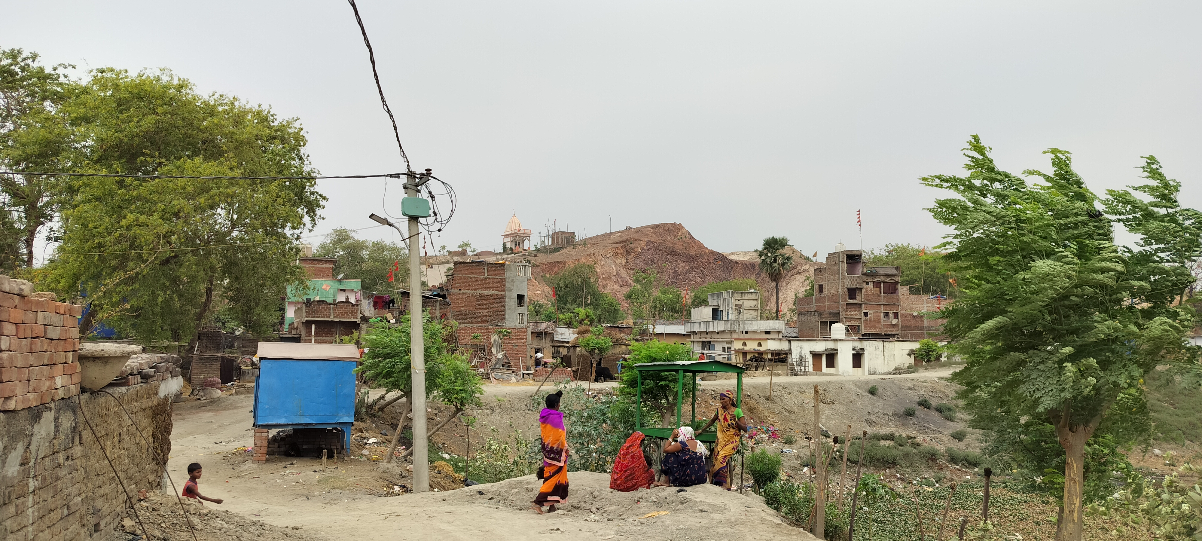
The large-scale mining of Pachnā Hill is a recent phenomenon that started around a decade ago. The people recall a cave-like structure atop the hill that contained ancient remains. Dr Harsh Ranjan and Dr Elora in 2020 saw this cave-like feature that yielded some ceramics and antiquities. There was a flat area on the hilltop with traces of brickbats (Tribedy 2021: 716). Dr Harsha noticed potsherds from the late mediaeval period on Pachnā Hill (Directorate of Archaeology 2020). He also found brickbats which he believes were remnants of some structure. This part of the Hill with the ‘cave’ and flat surface with brickbats was lost to mining in 2023.
I saw an image of the crowned Buddha kept in a corner of the Vajratārā temple. Manish Ji informed me that the image was recovered from the excavation of Pokhara in 2022. The crowned Buddha image has an inscription from 8th-9th CE reading, ‘the gift of an image by Dharmrakshit Suhath’. Pokhara is a 25-acre big waterbody at the foothill. The image is 17 in x 9 in x 3 in, broken into two. The two halves of the Buddha image are fixed with glue. The image was broken during the excavation of Pokhara. Manish Ji then took me to a few sculpture collectives in the village where I noticed a damaged head of the Buddha, amongst the Buddhist images. This 9-inch head belonged to some life-size image of the Buddha. According to villagers, these images including the ‘Pawan Chakkī’ and Vajratārā were recovered from the Pokhara at different times. A few villagers confided the Vajratārā image was secretly planted on the hill to protect it from further demolition. The villagers pointed at certain places in the Pokhara that had ancient big-sized bricks.
Kapotaka Monastery as per Xuanzang was on the north side of the Isolated Hill. Pachnā village is on the south/southeast of the Hill. Despite a scorching day, I thought of walking along the northern edge of the Hill to examine Barui and Kunḍā villages in the north of the Pachnā Hill. Walking more than one kilometre on a dusty road along the north edge of Pachnā Hill I reached Barui.
Just as Pachnā village is settled on the foot of the Pachnā Hill on its south/southeast corner, Barui is at the foot of the Pachnā Hill on its north. Numerous large and small water bodies surround Barui. The first thing that caught my attention was a mosque and graveyard at the southeast end of the village. The mosque is sitting on a conspicuous brick mound. The brick mound is around 12 feet tall, spread over a quarter of an acre. I was not allowed to measure the bricks but they looked ancient. The masjid mound looked like the remains of a stūpa. A central part of the village (Barui) is on raised ground, probably on an ancient mound.
The Pachnā Hill south of Barui is now obliterated owing to large-scale mining. People in Barui recounted fond memories associated with the Hill. The Hill, according to them, was tall and steep. Though the mining provided the villagers with short-term economic opportunities, they now realise and lament losing the Hill. I enquired with many people in Barui, young and old, and everyone denied having noticed any ancient remains (bricks and sculptures) on the Hill opposite the village. Many mentioned having seen ancient remains on the Hill but not on the Hill opposite their village (i.e. Barui) but on the Hill near Pachnā. There is a broken image of Buddha kept at the Middle School, Barui and a few fragments of ancient images at Mahārāni Sthān. The actual findspot of these images was unknown. According to the villagers, these broken images have been lying there for generations.
 |
| A broken image of the Buddha, Barui. |
 |
| Mosque settled on an Ancient mound, Barui. |
 |
| Exposed bricks, Masjid Mound, Barui. |
 |
| Sculpture Collective, Barui. |
 |
| Barui north of Pachnā Hill. Hill is now obliterated. |
 |
| Ongoing large-scale mining, Pachnā Hill. |
 |
| Scars of Mining, Pachnā Hill. |
The question is, do the ancient remains of Pachnā and Barui represent Kapotaka?
The Seikhpurā range is the only hill (range), ‘tall and precipitous’, ‘northeast of Indraśailaguhā’, and on the Nālandā-Munger track, befitting the descriptions of Xuanzang. Pachnā-Barui is the only known village in the Seikhpurā range of hills that has ancient Buddhist images in view and a potential stūpa mound in Barui. Most importantly Pachnā-Barui also fits the distance and direction mentioned by Xuanzang.
The two major works of Xuanzang, both of which talk about his pilgrimage to India, are his Records, i.e., Ta-Tang-Hsi-yü-chi (Records of the Western Lands of the Great Tang Period) and his Biography (Shaman Hwui Li’s Biography of Xuanzang). Both accounts have a different version of how Xuanzang travelled to Kapotaka. As per the Records (Rongxi 1996: 257), Xuanzang travelled to Kapotaka from Indraśailaguhā (Parwāti). However, as per the Biography (Beal 1914: 125), Xuanzang visited Kapotaka while on the way to Hiraṇyaparvata from Nālandā Saṅghārāma. So, which of the two descriptions of Xuanzang’s visit to Kapotaka is correct?
The Biography gives very vivid details about how Xuanzang was received by the monk-students of Nālandā Saṅghārāma at Mahābodhi (Bodhgayā). The Biography further mentions his travel to Nālandā Saṅghārāma and his first meeting with Śilabhadra, the head achārya of Nālandā Saṅghārāma. After he settled down at Nālandā, Xuanzang embarked on a pilgrimage to sacred traces of Buddha in the neighbourhood of Nālandā. It was during this pilgrimage that Xuanzang visited sacred traces in Rājagṛiha and Indraśailaguhā. After this short pilgrimage, Xuanzang stayed at Nālandā for a few years focusing on his studies ( Beal 1914: 125). After Xuanzang completed the examination of sūtras and śāstras at Nālandā, Xuanzang restarted his journey to visit sacred traces and practice under eminent śastra masters in other parts of India. Xuanzang left Nālandā for Hiraṇyaparvata (now Munger) to practise under eminent teachers Tathāgatagupta and Kshāntisiṁha. The Biography mentions Xuanzang ‘by the way came’ to Kapotaka while he was en route from Nālandā to Hiraṇyaparvata. Xuanzang stayed at Hiraṇyaparvata for one year and studied Vibhāshā and the Nyāya-Anusāra and other śāstras (Beal 1914: 125).
There is a perceptible difference in the approaches of both accounts. Records is a catalogue of places in a logical sequence. Records show that Xuanzang took a unidirectional route i.e., he followed a single path and advanced in only one direction. Biography on the other hand records the places Xuanzang visited in the exact sequence of visits. It is evident from the Biography that Xuanzang visited Kapotaka a couple of years after his visit to Indraśailaguhā. Also, as per the Biography, Xuanzang did not visit Indraśailaguhā when he went to Hiraṇyaparvata from Nālandā touching Kapotaka in between. This implies Xuanzang travelled to Kapotaka from Nālandā and not Indraśailaguhā as mentioned in the Records. And most likely the distance and direction of Kapaotaka from Indraśailaguhā provided in the Records is an estimate.
Biography is silent about the distance between Nālandā and Kapotaka. However, as per the Records, Kapotaka was 35-48 km (150-160 Li) northeast of Indraśailaguhā (Pārwati Hill). Barui is only 27 km as the crow flies northeast of Pārwati Hill. On the other hand, Barui is almost 45 km as the crow flies from the ancient remains of Nālandā, equivalent to 150-160 Li confirming the descriptions of Xuanzang.
The villages of Pachnā and Barui have Buddhist images from the 8th-12th CE. Excavations in these villages may reveal Buddhist monastic remains from early periods but still, this piece of evidence is not conclusive enough to qualify Pachnā-Barui as the ancient Kapotaka. There should be broken brickbats, and sculpture fragments all over the Hill and the slopes of Pachnā Hill. Xuanzang visited many Buddhist sites in Magadha that were on the hills like the Isolated Hill of Hiraṇyaparvata (Uren), Indraśailaguhā (Pārwati Hill), Buddhavana (Ayer Pathri), Prāgbodhi Hill (Dungeshwari), Guṇamati Monastery (Dharāwat), Śīlabhadra Monastery (Kawuā Dol). I have visited Uren, Pārwati, Ayer, Dungeshwari, Dharāwat and Kawuā Dol and noticed copious Buddhist antiquities on the Hill and the villages in the immediate neighbourhood. However, the corroboration of Xuanzang’s accounts in Pachnā Hill is now out of bounds. We have lost most of the Pachnā Hills.
The finds in Pachnā-Barui are not very encouraging yet, having surveyed the Sheikhpurā range of Hills, Pachnā-Barui is my best-educated guess to be the remains of Kapotaka Monastery.
Bibliography:
Beal, S.;1914, The life of Hiuen-Tsiang by Shaman Hwui Li by Kegan Paul. London: Trench Trubner and Co.
Beglar, J.D.; 1878, Report of a Tour Through the Bengal Provinces of Patna, Gaya, Mongir, and Bhagalpur; the Santal Parganas, Manbhum, Singhbhum, and Birbhum; Bankura, Raniganj, Bardwan, and Hughli; in 1872-73, Vol. VIII. Calcutta: Office of the Superintendent of Government Printing.
Buchanan-Hamilton, Francis.; 1925, Journal of Francis Buchanan Kept During the Survey of the Districts of Patna and Gaya in 1811-1812. Patna: Superintendent, Government Printing, Bihar and Orissa.
Cunningham, A.; 1873, Report for the Year 1871-72, Vol. III. Calcutta: Office of the Superintendent of Government Printing.
Cunningham, A.; 1882, Archaeological Survey of India. Report of a tour in Bihar and Bengal in 1879-80, Vol. XV. Calcutta: Office of the Superintendent of Government Printing.
Chaudhari, P. C.; 1936, The Cult of Tārā and an Image from Parbati. Journal of the Bihar and Orissa Research Society Vol XXII, Part IV. Patna: Published by the Bihar and Orissa Research Society.
Directorate of Archaeology, Department of Art Culture and Youth, Government of Bihar. 2020. Site Inspection Report. 5Pura/Ni. 3-02/2020.
Patil, D. R.; 1963, The Antiquarian Remains in Bihar. Patna: K. P. Jayaswal Research Institute.
Rongxi, Li.; 1996, The Great Tang Dynasty Record of the Western Regions. California: BDK America, Inc.
Tribedy, Elora.; 2021, Sinless’s Piety: A Recently Recovered Inscribed Image of Vajratārā Maṇḍala from Pachnā Hill, Bihar. Journal of Bengal Art, Vol. 26. Dhaka: International Centre for Study of Bengal
3 comments:
Your blog beautifully captures the spiritual essence and historical significance of various sacred sites. If you're interested in exploring a challenging yet spiritually enriching pilgrimage, the Shrikhand Mahadev Trek in Himachal Pradesh is a must-visit. It offers an incredible journey through the majestic Himalayas, culminating in a breathtaking view of the Shrikhand Mahadev Peak, where devotees seek the blessings of Lord Shiva.
Oh! Indian great Explorer dear Deepak Anand Ji march forward. Everyday you uncovered real Gem. Your tireless effort I highly appreciate. I wish your good health. I request Bharat Sarkar(central & local) unconditionally transfer the Buddha all holy places world Buddhist community. I think they are dedicated mind for developing it all. I believe Buddhism keep safe world may safe. Triple Gem bless you and your family. khemeshbar453@gmail.com
The incident of the Kapotaka monastery where Xuanzang throws three garlands after making three wishes brings this place to life.
Post a Comment