The ancient
kingdom of Kapilavastu, mentioned in the Buddhist literature as located in the
foothills of Himalayas, is situated across the present-day boundary between
Nepal and India. The Buddhist sites of Kapilavastu, mentioned in the accounts
of Chinese monk-scholars Faxian (Fahien, 5th century CE) and
Xuanzang (Hsüan-tsang, 7th century CE) and revealed in the
excavations in the past century, lie on either side of the India-Nepal border.
Consequently, both India and Nepal are responsible for protecting and promoting
these sites. Ideally, both countries should join hands in developing a
Kapilavastu Pilgrimage circuit that would integrate the sacred Buddhist
pilgrimage places on either side of the border. However, due to the clashing
claims between India and Nepal over the identification of ‘Palace City’ of
Kapilavastu — both countries claim the ‘Palace City’ to be lying within their
territory — an atmosphere of mistrust has developed between the two countries
leading to distrust stalling the idea of ‘Kapilavastu Pilgrimage’ indefinitely.
Let us understand this issue in detail.
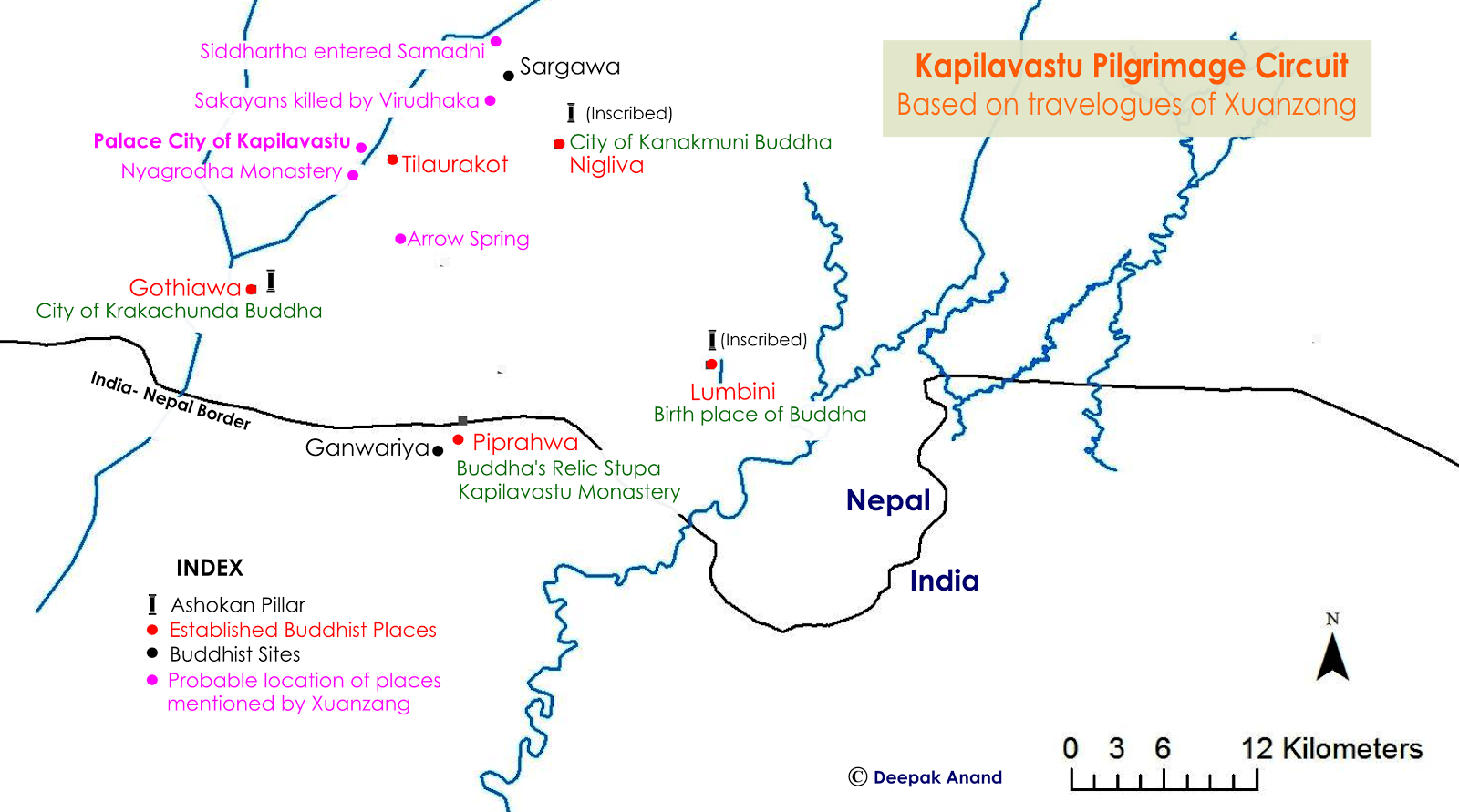 |
Map 1- Kapilavastu
Pilgrimage Circuit based on the description of Xuanzang
|
The name
Kapilavastu refers to the kingdom as well as the capital (administrative
center) of the Śākya dynasty, ruled in the 6th century BCE by King
Suddhodhana, the father of Prince Siddhārtha. Kapilavastu was the place where
Siddhārtha (the Buddha) spent his boyhood before renouncing worldly pleasures
in search of the truth. Faxian and Xuanzang both had visited the kingdom of
Kapilavastu on their journey to the Buddhist scared places in India. Xuanzang
writes that Kapilavastu was a kingdom with a circumference of 4000 Li (1300 kms
approx.) in circumference. Faxian too mentions Kapilavastu as a country, but
does not give its size. According to Xuanzang, the kingdom of Kapilavastu
contained a ‘Royal City’ or ‘Capital’ within which was a ‘Palace City’ or
‘Inner City’ about 15 Li (5 kms approx.) in circumference. Faxian neither refers
to ‘Royal City’ nor ‘Palace City,’ but instead mentions a ‘City of
Kapilavastu’. Faxian’s descriptions of the ‘City of Kapilavastu’ and Xuanzang’s
descriptions of ‘Palace City’ indicate that both are referring to a place where
King Suddhodhana lived and the Bodhisattva Siddhārtha (the Buddha) spent his
childhood. Xuanzang and Faxian both saw numerous shrines within the ‘Palace
City’/‘City of Kapilavastu’ and in its neighbourhood to mark places associated
with the Buddha, his mother, Mahāmayā, and his father, King Suddhodhana.
Therefore, it may be concluded that Xuanzang’s ‘Palace City’ and Faxian's ‘City
of Kapilavastu’ are the same place.
At the time of
Faxian’s pilgrimage to India, Kapilavastu was already in ruins. Faxian saw only
some monks and a score or two of families of common people at the ‘City
of Kapilavastu’. Two centuries later, Xuanzang had a similar experience to
share. He mentions of more than a thousand villages and monasteries lying in
ruins in the kingdom of Kapilavastu. In spite of the kingdom being in ruins,
both pilgrims found a small community of monks, who guided them to the sacred
Buddhist pilgrimage places. The sacred places mentioned by them can be grouped
into four set of places.
1. ‘Palace City’
(mentioned by Xuanzang)/‘City of Kapilavastu’ (mentioned by Faxian), henceforth
referred to as ‘City’.
2. Place of
Kanakmuni Buddha
3. Place of
Krakachunda Buddha
4. Birth place
of Gautama Buddha (Lumbīnī)
Both Faxian and
Xuanzang, had visited all these places, but in different sequences. Faxian
visited first the place of Krakachunda Buddha, from where he went to Kanakmuni
Buddha and then to ‘City’. Xuanzang visited first the ‘City,’ from where he
went to the places of Krakachunda and then Kanakmuni Buddha. Xuanzang mentions
seeing three Aśokan pillars in Kapilavastu kingdom at the birthplace of the
Buddha (Lumbīnī), the place of Kanakmuni Buddha and at the place of Krakachunda
Buddha. Faxian is silent about these Aśokan pillars. In the 1890’s, three
Aśokan pillars were actually discovered in Nepal at Rumandie, Niglivā and
Gothiāwā. The pillars at Rumandie and Niglivā have Aśokan inscriptions dating
from the 3rd century BCE establishing them to be the birth place of
the Buddha (Lumbīnī) and the place of Kanakmuni Buddha respectively. Obviously,
the third Pillar at Gothiāwā marks the place of Krakachunda Buddha. Some
scholars conjectured that the Aśokan pillars at Rumadie, Niglivā and Gothiāwā
were brought to these places from elsewhere. Research, however, shows their
speculation to be incorrect.
 |
Map 2- Map depicting pilgrimage of Faxian and Xuanzang in Kapilavastu kingdom
|
After the discovery of places of Kanakmuni Buddha, Krakachunda Buddha and Lumbīnī, the focus of archaeological exploration shifted to finding the fourth place — the ‘City’. Locating the site of the ‘City’ was not difficult because both Faxian and Xuanzang described the location of the ‘City’ with respect to the other three sites that were already established. When the early explorers who examined Faxian’s and Xuanzang’s description of the ‘City’ with respect to the sites of Lumbīnī, Niglivā and Gothiāwā — established on the basis of the Aśokan pillars as explained earlier — they found a contradiction. Faxian travelled 1 Yojan (10 kms approx.) in the East direction from Kanakmuni Place (Niglivā) to reach the ‘City;’ accordingly, the ‘City’ should be on and around B (refer to map 2). Xuanzang travelled 50 Li (16 km approx.) in the North direction of Karakchunda Place (Gothiāwā) to reach the ‘City;’ accordingly, the ‘City’ should be around A (refer to map 2). Summarising our findings till this point, we can say that if we follow Faxian’s descriptions, the ‘City’ lies at B, and if we follow Xuanzang’s descriptions, it lies around A. Further in the puzzle over the identification of the ‘City,’ we find that the locations of B and A are substantially apart on the map. But since the ‘City’ can be located only in one of the two spots — B or A — we are led to conclude that either Faxian's or Xuanzang’s description is inaccurate. To establish whose description is accurate, let us examine their respective travel accounts further.
 |
Broken Aśokan Pillar at
Lumbīnī at the time of discovery Pic: ASI
|
 |
Broken Aśokan Pillar of
Gothiāwā Pic: Cambridge University Press
|
 |
Broken Aśokan Pillar of
Niglivā with inscriptions
|
Faxian and
Xuanzang both travelled from the ‘City’ to Lumbīnī. Faxian travelled 50 Li (15
kms approx.) in the East direction from the ‘City’ to reach Lumbīnī. Xuanzang,
on the other hand, travelled 32 Li (10 km approx.) South-East of ‘City’ to
reach the Arrow Spring, from where he travelled 90 Li (27 kms approx.)
South-West to reach Lumbīnī. At present, Rumandie is identified with the site
of Lumbīnī. If both Faxian and Xuanzang arrived at Lumbīnī from the ‘City’,
then by charting their travel routes on the map, we should reach Rumandie.
However, that is not so. Faxian’s description leads to point C (refer to map
2). This means that the distance and direction of the ‘City’ provided by Faxian
are incorrect. The distance and directions of ‘City’ provided by Xuanzang, on
the other hand, are consistent with respect to Lumbīnī (Rumandie) and two other
Aśokan pillar sites. If we assume Xuanzang’s descriptions to be correct, then
based on these descriptions, the most probable place for the ‘City’ of
Kapilavastu appears to be in Tilaurakot and its surroundings (point A in map
2).
In 1962, at the request of His Majesty’s
Government of Nepal, Government of India appointed Ms. Debala Mitra,
Superintendent of Archaeological Survey of India (ASI), to survey Lumbīnī and
its surrounding. Mitra excavated at Tilaurakot, but could not find anything
substantial to support Tilaurakot as the remains of the ‘City’. Mitra’s
findings were a disappointment for Nepal. In her book Buddhist Monuments,
published in 1971, Mitra rejected Tilaurakot as the site of the ‘City,’ arguing
that the ‘City’ instead was Piprāhwā and its surrounding that lay on the Indian
side of the border.
Piprāhwā is a
village in Siddharthnagar District of Uttar Pradesh in India. Piprāhwā is 16
kms away from Rumandie, which is in Nepal, and 1.5 kms away from the
India-Nepal border. Piprāhwā is the place where in 1898, William Peppé
discovered relics of the Buddha from an ancient stūpa mound. The inscription on
one of the caskets containing the relics read that the relics of the Buddha
were the belongings of Śākyans. We know that the Buddha belonged to the Śākya
tribe, who were the rulers of the kingdom of Kapilavastu. The discovery of the
Śākyans share of the Buddha relics at Piprāhwā suggested that Piprāhwā and its
surroundings were not only an integral part of the kingdom of Kapilavastu but
was also an important place for the Śākyans. Peppé had excavated only the most
prominent mound at Piprāhwā which turned out to be the relic stūpa. The relic
stūpa was surrounded by many other mounds. Mitra expected that these mounds
would be the remains of Nyagrodha Monastery (Nyagrodhārāma).
According to
Buddhist tradition, in the first year after his enlightenment the Buddha
returned to Kapilavastu to meet his father, King Shuddhodhana. During this
visit, the Buddha stayed at Nyagrodha Park. At the Nyagrodha Park, the Buddha
preached the Dhamma to his father and
his Śākyan brethren. Many Śākyans embraced the Buddha’s teachings and joined
the Saṅgha. A monastery was built later at this place for the Śākyans
who became monks. This monastery was the Nyagrodhārāma. According to Xuanzang,
the Nyagrodha Monastery was 3-4 Li (approx. 1 km.) South of the ‘City’.
Mitra expected
the excavations at Piprāhwā to yield some inscription that would confirm the
site as the remains of the Nyagrodha Monastery. If Piprāhwā could be identified
as the site of the Nyagrodha Monastery, then ’City’ would be 1 km south of
Piprāhwā — on the Indian side. To substantiate her claim that the ‘City’ was in
the vicinity of Piprāhwā, Mitra referred to the accounts of Faxian. Faxian
travelled from Kanakmuni Place in the East direction to reach the ‘City,’ and
from the ‘City’ he travelled further East to reach Lumbīnī (refer to map 2). If
Faxian reached Lumbīnī by travelling in the East direction from the ‘City’,
then it means that the ‘City’ was in the West of Lumbīnī. Based on this logic, Mitra
argued that the ‘City’ should be in the West of Rumandie - point D in map 2 -
which coincides with Piprāhwā and its surrounding. We may say that Mitra’s
argument is not justified because she bases her theory on Faxian’s accounts. On
the Map 2, we see that Piprāhwā is on the West of Rumandie, which is the site
already identified as Lumbīnī. However, Faxian’s Lumbīnī should be at spot B in
Map 2. Piprāhwā is not on the West of spot B. Hence, Piprāhwā cannot be
the site of the ‘City’ according to Faxian's reference.
Mitra’s reports
encouraged Mr. K M Srivastava, Superintendent Archaeologist of the
Archaeological Survey of India to take up excavations in Piprāhwā and other
potential mounds in the its neighbourhood. Hoping to find some evidence that
would help in linking Piprāhwā to the ‘City,’ Srivastava began excavating at
Piprāhwā in 1971. Excavation revealed that the Relic stūpa of Piprāhwā was
surrounded by three monasteries. Many monastic seals were also discovered.
These were classified into three sets. (1) The first set of seals read Om
Devaputra Vihare Kapilavastu Bhikkhusaṁghasa (Om of the community of
monks of Kapilavastu in the monastery of kanishka/ huvishka). Twenty-one such
seals were discovered. The word Devaputra (son of the gods) was an
honorific title used by Kuṣāṇ king, Kanishka (126-150 century CE) and his
successor, Huvishka (150-193 century CE). (2) The second set of seals read Maha
Kapilavastu Bhikshusaṁghasa (Of the community of Buddhist monks of
great Kapilavastu). Thirteen such seals were found belonging to the Kuṣāṇ
period (2nd century BCE – 3rd century CE). (3) The third
set of seals carried names of monks. The inscriptions on the three sets of
seals together proved that the monasteries of Piprāhwā were established by Kuṣāṇ
kings for the community of monks of the kingdom of Kapilavastu.
Unfortunately
for Srivastava Piprāhwā turned out to be Maha Kapilavastu Monastery and not
Nyagrodha monastery as predicted by Mitra. So, ideally this was a closed case
but Srivastava still conducted more excavation in the south side of Piprāhwā,
at a village called Ganwariyā, hoping to find the remains of the palace of King
Suddhodana, and thereby establish the place as the site of the ‘City’.
Srivastava’s excavations, however, revealed Ganwariyā to be another monastic
site like Piprāhwā. In 1976, three years after the excavations at Piprāhwā and
Ganwariyā, the findings from these places were made public through a news item in
The Times of India tilted ‘Buddha’s Lost City of Kapilavastu Found.’ People in
Nepal saw this as India’s plot to deny Nepal claim over the Buddha’s homeland.
The claim of Indian archaeologists of having discovered the ‘City’ or even of
the ‘City’ being on the Indian side of the India-Nepal border is controversial
because, as we have seen, it lacks supporting evidence.
 |
Excavated monastic remains of
Piprāhwā
|
 |
Excavated monastic remains of
Ganwariyā
|
Explorers and
archaeologists like Alexander Cunningham, who successfully identified many
ancient places mentioned by Faxian and Xuanzang, found that Faxian’s
descriptions were often inconsistent in terms of distance and direction of
places. Consequently, they preferred to rely on the descriptions of Xuanzang.
Mitra and Srivastava, on the other hand, based their excavation and analysis on
Faxian’s description of the ‘City’ rather Xuanzang’s, without explaining why
they did so.
Mitra and
Srivastava both failed to notice the error in Faxian’s description. A careful
study of the descriptions by Faxian and Xuanzang and a little observation should
have helped them to realize that if we change Faxian’s direction of travel from
the Place of Kanakmuni Buddha (identified as Niglivā) to the ‘City’ from East
to West then the description of the ‘City’ and its neighbouring places
including the Arrow Spring and Lumbīnī provided by Faxian coincide with the
descriptions provided by Xuanzang. Map 3 shows Xuanzang’s route according to
his description, and Faxian’s route with the direction of travel changed from
East to West (refer to map 3). In the map, we see that the travel routes of
Xuanzang and Faxian actually coincide (or are similar), once we take Faxian’s
direction of travel as West instead of East.
 |
Map 3- Map depicting
travel of Xuanzang and Faxian (after ‘correction’)
|
A team from
Bradford University conducted a study in 1997 using Ground Penetrating Radar
(GPR) and found substantial evidence supporting Tilaurakot as the most likely
place of the site of the ‘City’. It may be argued that since no inscriptions
have been found at Tilaurakot, the place cannot be conclusively identified as
the ‘City’. However, we know many of the important Buddhist pilgrimage places
which were identified in the last century, namely Griddhakūṭa (Vulture’s peak),
Veḷuvana (Bamboo’s grove), Saṅkāsya, Prāgbodhi, Brahmayoni, were identified on
the basis of circumstantial evidences, that is to say, on the basis of
descriptions provided by Faxian and Xuanzang. In the case of locating the site
of the ‘City’, circumstantial evidences are strongly pointing to Tilaurakot and
its surroundings.
At present, India and Nepal both are promoting their claims of Kapilavastu causing a deadlock in archaeological exploration, analysis and identification. The attitudes of both the countries are criticisable because we know that boundaries of ancient kingdoms were not constant. Since Kapilavastu is an ancient kingdom, in the modern times, its parts may be spread across Nepal and India. Findings at Piprāhwā and Ganwariyā confirm that the remains of the Buddhist Kapilavastu are scattered on either side of the India-Nepal border. Xuanzang mentions about more than a thousand monasteries laying in ruins in Kapilavastu. The governments of India and Nepal should work together to explore, document, identify and develop the sites mentioned by Faxian and Xuanzang around the ‘City’, such as the place where after his enlightenment, the Buddha was received by his father, King Suddhodhana, for the first time, the place where the Bodhisattva Siddhārtha became absorbed in Sāmādhi (deep meditation) while watching ploughmen at work, and other places around the ‘City’ related with the Buddha. The governments of India and Nepal should also together develop the sacred places of Kapilavastu on either side of the India-Nepal border, such as Lumbīnī, Gothiāwā, Niglivā, Piphrāhwā, Ganwariyā and Tilaurakot, and promote pilgrimage and tourism to these places under the banner of the ‘Kapilavastu Buddha Trail’.
At present, India and Nepal both are promoting their claims of Kapilavastu causing a deadlock in archaeological exploration, analysis and identification. The attitudes of both the countries are criticisable because we know that boundaries of ancient kingdoms were not constant. Since Kapilavastu is an ancient kingdom, in the modern times, its parts may be spread across Nepal and India. Findings at Piprāhwā and Ganwariyā confirm that the remains of the Buddhist Kapilavastu are scattered on either side of the India-Nepal border. Xuanzang mentions about more than a thousand monasteries laying in ruins in Kapilavastu. The governments of India and Nepal should work together to explore, document, identify and develop the sites mentioned by Faxian and Xuanzang around the ‘City’, such as the place where after his enlightenment, the Buddha was received by his father, King Suddhodhana, for the first time, the place where the Bodhisattva Siddhārtha became absorbed in Sāmādhi (deep meditation) while watching ploughmen at work, and other places around the ‘City’ related with the Buddha. The governments of India and Nepal should also together develop the sacred places of Kapilavastu on either side of the India-Nepal border, such as Lumbīnī, Gothiāwā, Niglivā, Piphrāhwā, Ganwariyā and Tilaurakot, and promote pilgrimage and tourism to these places under the banner of the ‘Kapilavastu Buddha Trail’.
 |
| Tilaaurakot Area |
Special Thanks to Aparajita Goswami
Bibliography
Allen, Charles (2008). The Buddha and Dr Führer: An Archaeological Scandal (1st ed.). London: Haus Publishing.
Beal,
S.; 2005, Travels of Fah-hian and
Sung-Yun, Buddhist Pilgrims from China to India, Low Price Publications,
Delhi: riginally published London: Trubner and Co.: 1869).
Srivastava, K. M; 1980,
Archaeological Excavations at Piprahwa
and Ganwaria and the Identification of Kapilavastu. The Journal of the International Association of
Buddhist Studies, Volume 3, Number 1, University
of Wisconsin, Madison, USA.
Watters, Thomas; 2004, On Yuan Chwang’s Travels in India,
(Edited by T. W. Rhys Davids and S.W. Bushell), Reprinted in LPP 2004, Low
Price Publications, Delhi. (First published by Royal Asiatic Society, London, 1904-05).
4 comments:
Hi Deepak
Your article is vary short and nice. I can see that you visit lots of places,it increase my hunger to explore the world. I wish to go to Rajgir and also put all the relevant information to my blog but my journey was cancelled due to delay of Indian railways.details in http://www.holidaystory.in/rajgir-tour/
Thanks
Ruma Dey Baidya
Wow!!! It seems a very beautiful place.... Thanks for sharing this article...Very nice information for traveler ..thanks a lot for sharing this information.Thanks a lot for giving proper tourist knowledge and share the different type of culture related to different places. Bharat Taxi is one of the leading taxi and Cab Services provider in all over India.
very very interesting, In India, there is a lot of historical places to explore that's the reason India is the most fav place for me to explore. LOVE FROM LONDON
Fabulous amazing place beautiful pictures sharing. Thanks for sharing this informative and comprehensive blog. This is very interesting blog.
book cab
Post a Comment