
After traveling through Chen-chu (Ghazipur), Xuanzang arrived at Vaishali from Sarnath. The capital city Vaishali, 60-70 Li in circuit, was in ruins with very few inhabitants as described by Xuanzang (Life- Book-III, P-100). Within the city there was a royal precinct 4 to 5 Li in circuit. Based on the description by Xuanzang, the remains of Raja Vishal Ka Garh (Fig-1) have been identified as the Royal Precinct.
Read More- Li and Yojan
 |
| Xuanzang's journey to Vaishali |
A. Area of the Royal Precinct= 4 to 5 Li (Mean is 4.5 Li)
1 Li= 350 m (approximately)
Total circumference of the city in metres= 4.5 (Li) X 350 m= 1575 metres
2 X π X R = 1575 m
2 X 3.14 X R= 1575 m
Radius of the capital city (R) = 250 m
 |
Figure 1 - Royal Precinct, marked by a 250m radius circle on the toposheet
|
B- Area of the capital city- 60- 70 Li (mean is 65 Li)
1 Li= 350 m (approximately)
Total circumference of the city in metres= 65 X 350 m= 22750 metres
1 Li= 350 m (approximately)
Total circumference of the city in metres= 65 X 350 m= 22750 metres
2 X π X R = 22750 m
Radius of the capital city= 3622 m
 |
Figure 2- GIS projection of the capital city based on Xuanzang’s description
|
 |
Figure 3- Royal Precinct, capital city and present habitation
|
 |
Figure 4- Satellite image of the Capital City
|
If we plot a circle with radius of 3622 m around the royal precinct we can draw the approximate area/boundary of the palace city, Vaishali. (Fig-2).
Today, we find many present-day villages that are actually part of the ancient capital city, old foundations of which were seen by Xuanzang in the 7th CE (Fig-3).
Reviewing the descriptions of Vaishali and the surrounding area by Xuanzang and Fahein, we can identify six major points of interest visited by these monk pilgrims (see tables 3, 4, 5). At the time of Xuanzang, Vaishali was already in a dilapidated condition. Two hundred years before Xuanzang, Fahein found the entire area engulfed by forest. The descriptions of both Xuanzang and Fahein are tabulated in Table-2, below. In the tables below the places visited have been grouped together and numbered. In column one of Table 2, nine different groups of sites have been identified. These are 1) Royal Precinct, 2) Sangharama, 3) Chakramdas, 4) Kolhua, 5) Basokund, 6) Buddha Stupa, 7) Bowl Stupa, 8) Stupa for Chakarvartin Raja and 9) Stupa for 2nd council.
A careful observation of Xuanzang’s descriptions from his “Life” and “Travels” reveals that he stayed in a Sangharama (2nd Group) in Vaishali and traveled from this point to the other sites (see Table 3). Outside of the capital city of Vaishali, Xuanzang mentions the Royal Precinct as his point of reference. The description of the Ashokan Pillar (4th Group – Kolhua) is well established beyond any doubt and is thus used as our reference point for GIS distance measurement.
Fahein, when compared to Xuanzang’s pilgrimage did not record visiting sites in groups 1, 2, 4, and 5. Fahein who described this area of Vaishali as a dense forest, only focused on sites around the Buddha Stupa (6th Group), as is evident in Table 2. Column 2 describes the movement (From-To) of Xuanzang within Vaishali and places outside Vaishali.
 |
Table 2- Matrix of Description of Fahein and Xuanzang
|
 |
Table 3- Analysis of the Xuanzang's Description
|
Archaeological Profile based on the accounts published in Directory of Bihar Archaeology- B. P Sinha, Page-210 to 226
Phases of excavations at Vaishali and around began with a systematic excavation in 1903-04 by Bloch, followed by Spooner in 1913-14. A large excavation covering a wide area resumed in 1958 through 1962. This excavation was carried out by K.P Jayaswal Research Institute under Dr. A.S Altekar and S.R. Rai. Tabulated below in Table-4 is the summary of excavations at various sites.
The excavations were partial and in most of the cases just trail trenches were taken to ascertain the earliest settlements pattern. As evident from the table, more is still needed to be done. Except for the Relic Stupa (Table-4) and the Royal Precinct (Raja Vishal ka Gadh) most of the other places require further systematic excavation work.
 |
Figure 5-GIS Projection of Xuanzang’s Description (Vaishali)
|

 | ||
| Figure 6- GIS projection of Xuanzang’s Description on Toposheet |
 |
Figure 7 - Archaeological Profile of Vaishali based on Excavation reports
|
Place-1- Royal Precinct
Lat and Long- 26° 59’ 12 N, 85° 7’ 34 E
The identification of Raja Vishal ka Gadh (the Mound of King Vishal) as the remains of the Royal Precinct was done by A. Cunningham in 1861-62 (ASI, AR-1, p-98-185) on the basis of Xuanzang’s description. Excavations carried out by Bloch (ASI, AR-1903-04, p-18) and Spooner (ASI, AR-1913-14, p-55-56) found much secular sealing and a few seals from the 3rd century BCE suggest this to be an ancient site. Excavations in 1950 by Krishnadeva revealed two different phases of fort construction. The earlier phase was resting on a layer of NBPW (northern black polished ware) and some PGW (painted grey ware) shreds were found. All of the finds indicate that this site was a vibrant place in the 6th century BCE (Ref- Directory of Bihar Archaeology- B. P Sinha, P- 211).
 |
Figure 8 -Satellite image of the remains of the Royal Precinct
|
 |
Figure 10- Raja Vishal ka Gadh (Royal Precinct mentioned by Xuanzang
|
 |
Figure 9- Excavated Remains at the Royal Precinct of Vaishali
|
2nd Group of places- Chakramdas
Lat & Long- 26° 59’ 42 N, 85° 6’ 31 E
 |
Table 5- 2nd Group of Places
|
The village, Chakramdas, is settled over an ancient mound. At the centre of the village is a high mound called “Nonkhar”, by the villagers. The Nonkhar is a stupa shaped mound almost 30 ft high at the centre and quite possibly one of the stupas mentioned by Xuanzang. Explorations by P.C Mukherji in 1897 and Bloch in 1903 (Ref-The Antiquarian remains of Bihar, D.R. Patil p-29) were done to establish the link between the account by Xuanzang and the antiquities found in this surrounding area. Some excavation in the village Chakramdas revealed it to be a very ancient village with occupational deposits dating between 500 BCE and 500 CE.
 |
Figure 11- 2nd group of Places- Village Chakramdas
|
 |
Figure 12 -Surface Potsherds of the Village Chakramdas
|
 |
Figure 13- High stupa-like mound at the centre of the Village Chakramdas
|
3rd Group of places—Relic Stupa
Lat and Long- 26° 59’ 47 N, 85° 7’ 1 E
Lat and Long- 26° 59’ 47 N, 85° 7’ 1 E
Based on the description of Xuanzang, excavations were carried out at this site from 1958 to 1962. The highlights of the excavations were,
- The mound was 2’ 10” high and 50’ in diameter
- The mound was disturbed and brick robbing were reported
- The stupa was built from layers of piled-up mud.
- Stupa was enlarged with new bricks four times after its initial construction
- Seven layers were demarcated
- The 4th (also last) enlargement took place in the 1st century CE, 3rd enlargement in the 2nd century BCE, 2nd enlargement in the 3rd century BCE, and 1st enlargement took place from 350-250 BCE, and the finds suggest the stupa was built in 550-660 BCE.
- A relic casket was found during the course of excavation, it contained only ashes with some earth, and one punched marked coin, two glass beads, one conch, and one thin small piece of gold.
- Excavations revealed that the casket was removed from its original place and redeposit at a higher height during the first enlargement. (Ref- Directory of Bihar Archaeology- B. P Sinha, P- 212-13)
- Excavation around the relic stupa suggests there was a change in the river bed of the River Gandak around 100 CE. Because the relic stupa was surrounded by the river for a long period of time, the foundations of the stupa were undermined (Fig-15, 16 and 17).
 | ||
Figure 14 Excavated remains of the Relic Stupa
|

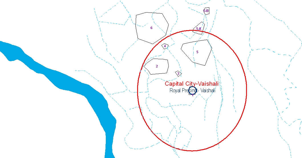 |
Figure 16- Old river beds of the River Gandak in and around ancient Vaishali
|
 |
Figure 17- Excavation in progress at Relic Stupa (in 1958-1962) (Pic-Courtesy ASI)
|
Lat and Long 26° 0’ 46 N, 85° 6’ 29 E
 |
| Table 6- 4th Group of Places |
The Ashokan Pillar was first reported by Mr. Law in January 1784. A sketch was made by J. R. Elphinstone in 1814 and the first descriptive account of this pillar was published by Stephenson in 1835. In 1861 and 1880 Cunningham executed detailed exploration and provided some substantial data about the site in consonance with Xuanzang’s travelogue.
 |
Figure 18- Ashokan Pillar and Stupas at Kolhua Site
|
As per the local tradition, the pillar was a walking stick of the legendary mythological character Bhimsen of epic Mahabharata. Excavation revealed the pillar with the lion capital to be 12.65 m, highly polished except for the lower portion 1.68 m from the base. The lion capital measures 3’ 6”. The stupa and the tank mentioned by Xuanzang have been successfully excavated.
Cunningham in 1861 found a sanyasi settled down near the pillar with a small residence and a court-yard enclosing the pillar (Fig-20). Prior to Cunningham, Stephenson mentioned in 1835 a similar account of this being converted to a place of worship. The pillar when discovered was just 18’ exposed in the court-yard of a 10’ high mound. (Ref-The Antiquarian remains of Bihar, D.R. Patil p-210-213)
5th Group of Places - Basokund
Lat & Long- 26° 0’ 24 N, 85° 7’ 47 E
 |
Figure 19- Excavation in progress at Kolhua
|
 |
Figure 20- First images of Ashokan pillar as discovered in 19th century(Courtsey-ASI)
|
Lat & Long- 26° 0’ 24 N, 85° 7’ 47 E
 |
Table 7- 5th Group of Place
|
Xuanzang’s description takes us to a place called Basokund. This place has no visible remains like mounds and surface pottery from ancient times. V. Smith in his report has suggested the villages Chak Abora and Abu Chak as places to look for this set of places mentioned by Xuanzang. Both of the villages are in the immediate surrounding area of Basokund. Basokund is an important pilgrimage place for Jains, the followers of the Lord Mahavira. Jains’ believe that the Lord Mahavira birth place Kundalgrama and his village Vaniyagrama to be in this locality. The village Bania (near Basokund) has revealed some Jaina antiquities as mentioned by V. Smith. Hoernle has identified Basokund as Kundalgrama (Ref-The Antiquarian remains of Bihar, D.R. Patil p-34). But the most appropriate site for the Xuanzang description is Village Birpur (5-A) in Fig-22.This place has very rich antiquities suggesting it was a flourishing habitation site in ancient times (See table-3). Village Birpur and immediate surrounding are the most appropriate places for the Amrapali House and Vimalakirti House.
6th Group of Places
Lat and Long -26° 1’ 24 N, 85° 5’ 59 E
 |
Figure 21- Jain Pilgrimage centre at Basokund
|
 |
Figure 22- GIS projection of Xuanzang’s description
|
6th Group of Places
Lat and Long -26° 1’ 24 N, 85° 5’ 59 E
 |
Table 8- 6th Group of Places
|
This group of places (Table-8) is mentioned in detail by Fahein and Xuanzang. Fahein probably did not visit further east towards the Relic Stupa and Ashokan Pillar site. Both of the pilgrims mentioned the multitude of relics from Buddha’s time in this area and a few prominent relics were described in great detail by both the pilgrims. Fahein suggests the 6th group of places to be outside the “City”, and we see village Bakhra is outside the “Capital City”, described by Xuanzang (Fig-23). Another evidence for Bakhra group of mounds to be appropriate for the 6th group of description (Table-8) is that this group mentions about the stupa to mark Buddha taking last glace at the Vaishali city as he left for Kushinara, and, this place should obviously be outside the city area as Bakhra is. The ancient remains at Bakhra Village is full of mounds and ancient remains, but the whole mound of Bakhra is now occupied by houses and modern structures. Few mounds in the vicinity are still prominent and it is possible that these high mounds are actually remains of the ancient stupas described by both the pilgrims.
Bakhra group of Mounds
Whole of the Bakhra Village is actually a big mound with a few mound very prominent suggesting to be some stupa remains. We identified 8 such stupa shaped mounds in the village as mentioned in map Fig-24 to 26. The ancient remains in shape of mound (Fig as 27 to32) are amid habitation and are in very bad shape.
 |
| Fig-23- Bakhra Group of places same as mentioned by Fahein |
 |
| Fig-24- Identified Mound in Bakhra village |

 |
| Fig-25- A closer view of placement of Mounds |
 |
| Fig-26- The Mound placement on the Toposheet |
 |
Figure 27- Aerial View of Stupa 1 and 2 of Fig 24 -26
|
 |
Figure 28- view from East of Stupa 1 and 2 of Fig 24-26 (Bakhra)
|
 |
Figure 29- Mound 7 & 8 of Fig no-24-26
|
 |
Figure 30- Mound no-6 of Fig 24-26
|
 |
Figure 31- Mound 3 of Fig- 24-26
|
 |
Figure 32- Mound 5 of Fig 24-26
|
Fahein’s “City”
The description by Fahein has some confusion regarding the direction and distances of the places. He has grouped the double-galleried Vihara and Ananda’s half body relic tope together and has placed them north of “City.” Whereas Xuanzang has placed both of them NW of the Sangharama (2 in Fig-23), and the Sangharama is 3-4 Li N of the Royal Precinct (1 in Fig 23). Ideally both of the stupas should be 12 to 15 Li NW from the Royal Precinct. This puts a question mark as to what Fahein means when he mentions “City.” Both of the stupas being discussed are part of the 6th Group of places (6 in Fig 23), and in fig-23 we find it should be outside the palace city. Fahein in his description has mentioned the three group of places (stupas and structures) that he mention with respect to “City” (Table-9), but Xuanzang places all three sets (of Fahein) of places in 6th group of places NW of the Royal Precinct (6 in Fig 23).
The description by Fahein has some confusion regarding the direction and distances of the places. He has grouped the double-galleried Vihara and Ananda’s half body relic tope together and has placed them north of “City.” Whereas Xuanzang has placed both of them NW of the Sangharama (2 in Fig-23), and the Sangharama is 3-4 Li N of the Royal Precinct (1 in Fig 23). Ideally both of the stupas should be 12 to 15 Li NW from the Royal Precinct. This puts a question mark as to what Fahein means when he mentions “City.” Both of the stupas being discussed are part of the 6th Group of places (6 in Fig 23), and in fig-23 we find it should be outside the palace city. Fahein in his description has mentioned the three group of places (stupas and structures) that he mention with respect to “City” (Table-9), but Xuanzang places all three sets (of Fahein) of places in 6th group of places NW of the Royal Precinct (6 in Fig 23).
Xuanzang’s 6th Group of places (Fig 23)
 |
Figure 33- Supposition-1 (Xuanzang’s description)
|
 |
Figure 34- Supposition 1, (Xuanzang’s Description)
|
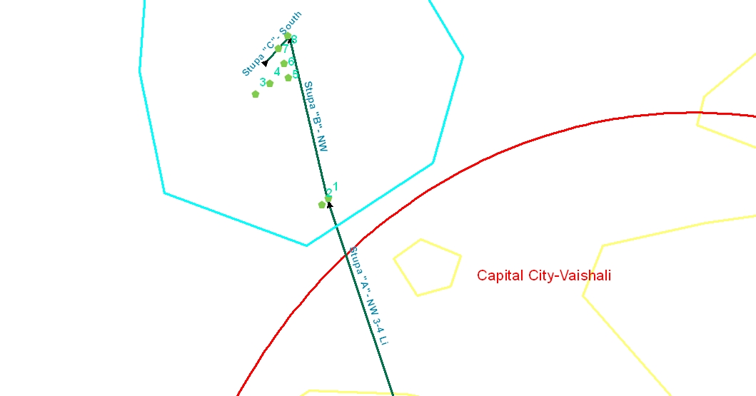 |
Figure 35- Supposition 2 (Xuanzang’s Description)
|
The Bakhra which as per Xuanzang’s description should be in the 6th Group of places is a large area and the mounds are scattered among this large area. We find that, in and around Vaishali, Fahein’s “East”, conflicts with Xuanzang’s “South.” For example, as per Xuanzang, Ananda’s Parinirvana place should be southeast of Vaishali but Fahein mention this to be east. The “Bowl Stupa” as per Xuanzang should be northwest of Vaishali but Fahein mentions this to be west of Vaishali.
One thing evident from Fahein’s description is that he visited only the 6th Group of places (Fig-23) and did not visit the rest of the groups of sites, which were amid dense forest or surrounded by water. We have tried to group Fahein’s description and match it with Xuanzang’s description in order to reach some conclusion about the “City” mentioned by Fahein (Table 9).
 |
Table 9- Fahein’s description clubbed with Xuanzang’s description
|
At the core of the puzzle of Fahein’s description is “Ambapali Vihara,” which according to him was in the “City.” Xuanzang described Ambapali twice: first mentioning Ambapali’s residence in the 5th group of places (Fig-23) and again him mentioning Ambapali’s garden and Vihara in the 6th Group of places (fig-23). In the City area, Xuanzang talks about one monastery in 2nd group of places (Fig-23). Fahein possibly stayed at Ambapali Vihara that was in “City”, and he visited other places from the Ambapali Vihara in “City”. Xuanzang also stayed in a monastery and he too mentions the places in reference to the Sangharama (2 in Fig 23). This Sangharama where Xuanzang stayed is part of the “Palace City” area as per the Xuanzang description (Fig 23). It is possible both the Pilgrims stayed in the same monastery and that Fahein made a mistake in taking note because if we take Fahein’s “Ambapali Vihara” to be the same as Xuanzang’s Sangharama (monastery) in the 2nd Group of places a comparative conclusion can be reached. Also in that case, the distances and direction mentioned by Fahein for his places are in agreement with Xuanzang’s description.
 |
Table 10- Building on the Fahein’s description
|
The table-10 is prepared with the premise that Xuanzang’s Sangharama (2nd Group of places, Fig-23) is the same as the “Ambapali Vihara” described by Fahein (Fig-36).
- We observe stupa “C”, described by Xuanzang is aligned “3 Li northwest” and “3 Li south,” as well.
- It appears that stupa D, E, C and B of Xuanzang are in close proximity and among the stupas D, E, C and B, “D” is at the north, “B” is in south and “E” and “C” in between.
- Stupas G and H of Xuanzang appear to be in a direction east of stupas D, E, C and B.
- Stupas A and A1 of Fahein are nearest to the “City” and this goes well with Supposition-1 for Xuanzang description fig no-34
- The Table suggests that Fahein’s “South” should not be an actual “South”, but rather relative to the structures as “Northwest.” The premise for this observation is that stupa “C” of Xuanzang is in both of the groups “northwest of the City” and “south of the City” groups described by Fahein.
Based on the match between Fahein and Xuanzang description (table-10) we have a conjecture of the Stupa alignment for the Fahein’s description in Fig- 36.We tabulate the suppositions and findings to find most appropriate alignment of the mounds (Ancient remains) of Bakhra village:

 |
Figure 36- Fahein’s Description for Vaishali
|
Description of 7th, 8th and 9th group of Places
7th and 8th group of places from Table 8
“Alms-Bowl Offering” of Licchavis and Stupa of the “Chakarvartin Raja”
Although the event of the “Bowl Offering” is not mentioned in the Mahaparinirvana Sutta, both of the pilgrims mentioned the “Bowl Offering” place of the Licchavis but with very little unanimity in their accounts as to the actual site. The exception is that both pilgrims agree on the story of the event. As per the story, the Licchavis of Vaishali accompanied the Buddha on his last journey to Kushinara despite the Buddha requesting them to return back. They would not go back and at reaching this point, the Buddha offered the Licchavis his alms-bowl as a pledge of his regard. Xuanzang mentions a great stupa erected at the place of this event. Fahein visited the “Bowl offering” place while on his way from Kushinara to Vaishali. “Bowl offering” as per Fahein description is almost equidistant from Kushinara and Vaishali. He traveled 12 Yojan from Kushinara to reach the Bowl offering place and found a Stone Pillar engraved with the sequence of events and he is silent about the Stupa. He traveled 10 Yojan further to reach Vaishali. Xuanzang on the other hand gives his description of the “Bowl offering” and further the “Chakarvartin Raja” stupa from Vaishali. While Fahein is silent about any stupa at this place, Xuanzang is silent about any Pillar at the place. Xuanzang’s Biography by Hwui Li (Life) doesn’t mention Xuanzang visiting these stupas but his “Records of Western Regions,” (Travels) has a description of these stupas as “Great.” We cannot deny the possibility of Xuanzang not visiting the place himself but possibly collected the information from people in Vaishali (as he did many other times in his travelogue).
In the direction mentioned by Xuanzang and Fahein lie two big Stupas at Keshariya and Nandangarh and two pillars at Areraj and Nandangarh. The question is which place among this fits both Xuanzang’s and Fahein’s descriptions. We will first explore Fahein’s description of two stone pillars between Rampurwa (Kushinara) and Vaishali. The first pillar is at Lauriya Nandangarh and the second at Areraj.
The value of “Yojan” varies from 8 km to 10 km. For our purposes, we will use the estimated distance of 9 km equals 1 Yojan and 350 m equals 1 Li.
Fahein traveled 12 Yojan SE to reach the “Alms-bowl” stone pillar, or 108 km, which fits perfectly for Rampurwa to Areraj (103 km) (Table 12, Fig-37). But from the Bowl Stupa, he traveled 10 Yojans to reach Vaishali, or about 90 kilometers. The actual distance between Areraj and Vaishali is only 53 kilometers. This discrepancy may have been due to the different demography of the time. Other factors may have been Fahein’s age (in his 60s). We do know that Fahein made other such errors in his details about other places he described.
 |
Table 11
|
“Alms-Bowl Offering” of Licchavis and Stupa of the “Chakarvartin Raja”
Although the event of the “Bowl Offering” is not mentioned in the Mahaparinirvana Sutta, both of the pilgrims mentioned the “Bowl Offering” place of the Licchavis but with very little unanimity in their accounts as to the actual site. The exception is that both pilgrims agree on the story of the event. As per the story, the Licchavis of Vaishali accompanied the Buddha on his last journey to Kushinara despite the Buddha requesting them to return back. They would not go back and at reaching this point, the Buddha offered the Licchavis his alms-bowl as a pledge of his regard. Xuanzang mentions a great stupa erected at the place of this event. Fahein visited the “Bowl offering” place while on his way from Kushinara to Vaishali. “Bowl offering” as per Fahein description is almost equidistant from Kushinara and Vaishali. He traveled 12 Yojan from Kushinara to reach the Bowl offering place and found a Stone Pillar engraved with the sequence of events and he is silent about the Stupa. He traveled 10 Yojan further to reach Vaishali. Xuanzang on the other hand gives his description of the “Bowl offering” and further the “Chakarvartin Raja” stupa from Vaishali. While Fahein is silent about any stupa at this place, Xuanzang is silent about any Pillar at the place. Xuanzang’s Biography by Hwui Li (Life) doesn’t mention Xuanzang visiting these stupas but his “Records of Western Regions,” (Travels) has a description of these stupas as “Great.” We cannot deny the possibility of Xuanzang not visiting the place himself but possibly collected the information from people in Vaishali (as he did many other times in his travelogue).
In the direction mentioned by Xuanzang and Fahein lie two big Stupas at Keshariya and Nandangarh and two pillars at Areraj and Nandangarh. The question is which place among this fits both Xuanzang’s and Fahein’s descriptions. We will first explore Fahein’s description of two stone pillars between Rampurwa (Kushinara) and Vaishali. The first pillar is at Lauriya Nandangarh and the second at Areraj.
 |
Table 12- Distances between places for Fahein’s Bowl offering Pillar
|
Fahein traveled 12 Yojan SE to reach the “Alms-bowl” stone pillar, or 108 km, which fits perfectly for Rampurwa to Areraj (103 km) (Table 12, Fig-37). But from the Bowl Stupa, he traveled 10 Yojans to reach Vaishali, or about 90 kilometers. The actual distance between Areraj and Vaishali is only 53 kilometers. This discrepancy may have been due to the different demography of the time. Other factors may have been Fahein’s age (in his 60s). We do know that Fahein made other such errors in his details about other places he described.
Areraj Pillar is an inscribed pillar but according to Fahein’s records the inscription mention about the event of “Alms-bowl offering”. While script had changed a lot in the centuries between Ashokan Brahmi (3rd century BCE, when it was inscribed) and the Gupta Brahmi (5th century CE when Fahein visited), there is a possibility that nobody with Fahein could read the inscription and so he may have just mentioned the tradition already existing at the place.
Xuanzang mentioned the “Alms-bowl” Stupa to be 50-60 Li northwest; or 20 kilometers. In this case Keshariya Stupa is very far (48 km) (table-12, Fig-37).
There can be two possibilities
- The Bowl Stupa is somewhere between Keshariya and Vaishali and the place needs more investigation. But we have to always remember Xuanzang says this stupa to be a “Great” Stupa suggesting big size of the structure.
- We have to consider the fact that Xuanzang mentions a great Stupa, and Keshariya stupa (Fig-40) is the first big stupa we encounter as we move out of Vaishali towards the Kushinara. Also in his “Biography”, there is no mention about these two stupas. These two stupas find mention in his “Records” and it is possible that he may not have visited the place himself but as a devout pilgrim for record purpose, he just collected the best of information as possible at Vaishali. And if we take this with Fahein’s description of an inscribed pillar at the place, then Keshariya stands a fair chance because an inscribed pillar at Areraj is just 5 kilometers from the Keshariya Stupa and these structures are part of the same area.
 |
Figure 37- Kushinara to Vaishali
|
 |
Figure 38- Areraj Pillar
|
 |
Figure 39- Inscription over the Areraj pillar
|
 |
Figure 40- Keshariya Stupa (More than 110 Ft High)
|
 |
Figure 41- Nandangarh Pillar
|
Stupa of Chakarvartin Raja
Xuanzang mentions about another great stupa 200 Li NW of Vaishali. This stupa has some connection with Jataka where the Buddha as a Bodhisattva was king called Mahadeva of this place. Xuanzang says this city to be “old and long-deserted”.
Cunningham in his report has suggested the Keshariya stupa to be more appropriate for the description. Our study suggests Keshariya to be more appropriate for the Alms-bowl stupa and Lauriya Nandangarh stupa (Fig-43) best suited for the 2nd stupa i.e. “Chakarvartin Raja” stupa. As per the Xuanzang’s description this was 200 Li North-west, this is approximately 70 Kms (@ 350 Mts/ Li) and the distance between Nandangarh Stupa and Vaishali is 105 Kms, need not mention we have already discussed Xuanzang probably didn’t visit the place himself and collected the information at Vaishali, hence an error for distance should be discounted. The vast ancient antiquities spread in Nandangarh suggest this to be a very ancient place and fits the description. The place has many ancient Burial stupas (Fig-42) from Vedic times as suggested by the excavations here. The place also boasts of an Ashokan Pillar suggesting this to be an important place possibly a trade route.
The big Buddhist stupa in the middle of the city suggests this to be an important stupa to mark some important event as Xuanzang has mentioned.
 |
Figure 42- Cluster of Burial Stupas at Nandangarh
|
 |
Figure 43- Nandangarh Stupa
|
2 comments:
Your article is very important, nice post, awesome, but what you know.
कया आप जानते हैं।
Dry Cough Medicine
Life insurance 2020 New plans
Lover Boy Hindi Shairy
Vestige Marketing | घर बैठे पैसा कमाने का सूनहरा अवसर
Computer trick and technic
rockmoney
key line times news
Amazon offer zone
offer zone shopping
shorterlife
You have put great effort to review and improve past researches over two centuries. I will be going thru all the psost.
In the meantime, which is the river flowing to west of Vaishali? Was there a river named Vashala as per the two Chinese?
Regards
Post a Comment