|
The community-built shrine dedicated to Dronāchārya inside the ‘capital city’. |
After a year-long break, I resumed my foot journey Retracing Bodhisattva Xuanzang (RBX) from Kāshipur, Uttar Pradesh on October 6th 2022. The RBX foot journey project was set into motion in February 2020. Xuanzang (Hsüan-tsang) was a Chinese Buddhist monk-scholar who visited the Indian Subcontinent in the 7th CE. Xuanzang’s account of his 16 years of travels in the Indian Subcontinent played a pivotal role in the resurrection of the Buddhist geography of India in 19th CE. The central idea behind the RBX foot journey project is to explore and document the present situation of the sites related to the sacred footsteps of the Buddha.
Within a month of the start of the foot journey COVID pandemic disrupted the planned schedule. Frequent COVID lockdowns had compelled me to split-up the foot journey into smaller sections. By July 2021, I had completed 2100 kms of the Xuanzang trail, exploring the sites related to the wanderings of the Buddha in Haryana, Uttar Pradesh and Bihar in India and Southern Nepal.
The present section of foot journey is approximately 400 kms long starting from Kāshipur (ancient Goviṣāṇa?) ending at Hulas Kherā touching Ahichhatra, Kannauj and Newal (ancient Navadevakula).
 |
| The present section of RBX foot journey. |
Present day Kāshipur in Uttrakhand was identified by Sir Alexander Cunningham as the ancient Goviṣāṇa mentioned by Xuanzang. Cunningham identified the remains of an old fort (29° 12' N. 78° 58' E) near the village of Ujain, which is just one mile to the east of Kāshipur as the ancient ‘capital city’ of the then country of Goviṣāṇa. According to Xuanzang, the Buddha had visited the capital city of Goviṣāṇa. Xuanzang mentions a 200 ft Ashokan stūpa to mark the place where the Buddha preached for a month (Rongxi 1996: 116). The stūpa was situated in an old monastery beside the capital city. Beside the Ashokan stūpa there were traces where the four past Buddha’s used to sit and walk up and down. Alongside the traces there were two more stūpas, each over ten feet high, containing hair and fingernail relics of the Historical Buddha.
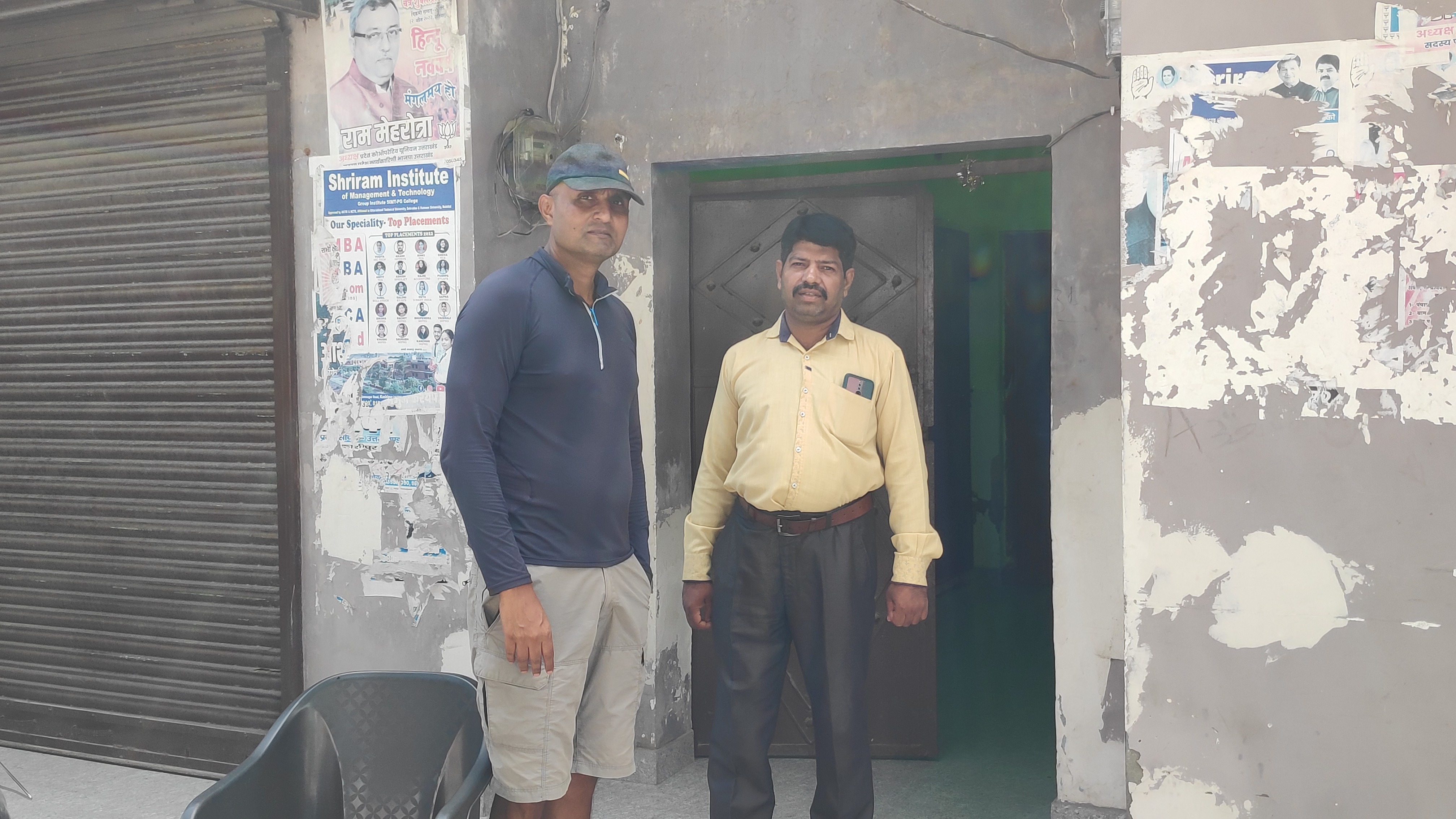
Cunningham, who visited Kāshipur in 1862-63, noticed many archaeological mounds in the vicinity of the ‘capital city’. The survey map prepared by Cunningham served as a reference for my explorations in Kāshipur. Shri Manoj Saxena, Superintending Archaeologist, Dehradun Circle was kind enough to assign Shri Ranjeet Negi, a staff of Archaeological Survey of India (ASI) Kāshipur office to guide me around. The remains of the ‘capital city’ are now popularly known as ‘Dronāchārya kā kilā’, i.e. palace of Dronāchārya. Dronachārya was teacher of the legendary Pāndava brothers of Epic Mahābhārata. Local people believe that the Pāndava brothers built this City/Palace for their teacher Dronāchārya. I noticed a community-built shrine dedicated to Dronāchārya inside the ‘capital city’. Excavation of Bhim-gaja, the biggest mound inside the ‘capital city’ has revealed it to be a Brahmanical Temple, a Panchayātana complex built in three different phases. The earliest period of the temple dates 5-6th CE. One of the major highlights of the excavations of the ‘capital city’ was the discovery of painted grey ware pottery. PGW pottery has been dated to 1,100 to 800 BCE.
Much has changed in the last 150 years, since the visit of Cunningham to Kāshipur. Walking around the outer boundary of the ‘capital city’ with Ranjeet, I noticed a number of habitations touching and often settled over the archaeological remains. These habitations are non-existent in Cunningham’s map of Kāshipur. Ranjeet told me ASI is regularly reporting the incidents of encroachment, which is a contravention of ASI laws, to the District Administration, but there is political interference and lack of Administration will to prevent it.
 |
ASI entrance gate, Dronāchārya ka Kilā (ancient Goviṣāṇa city/‘capital city’). |
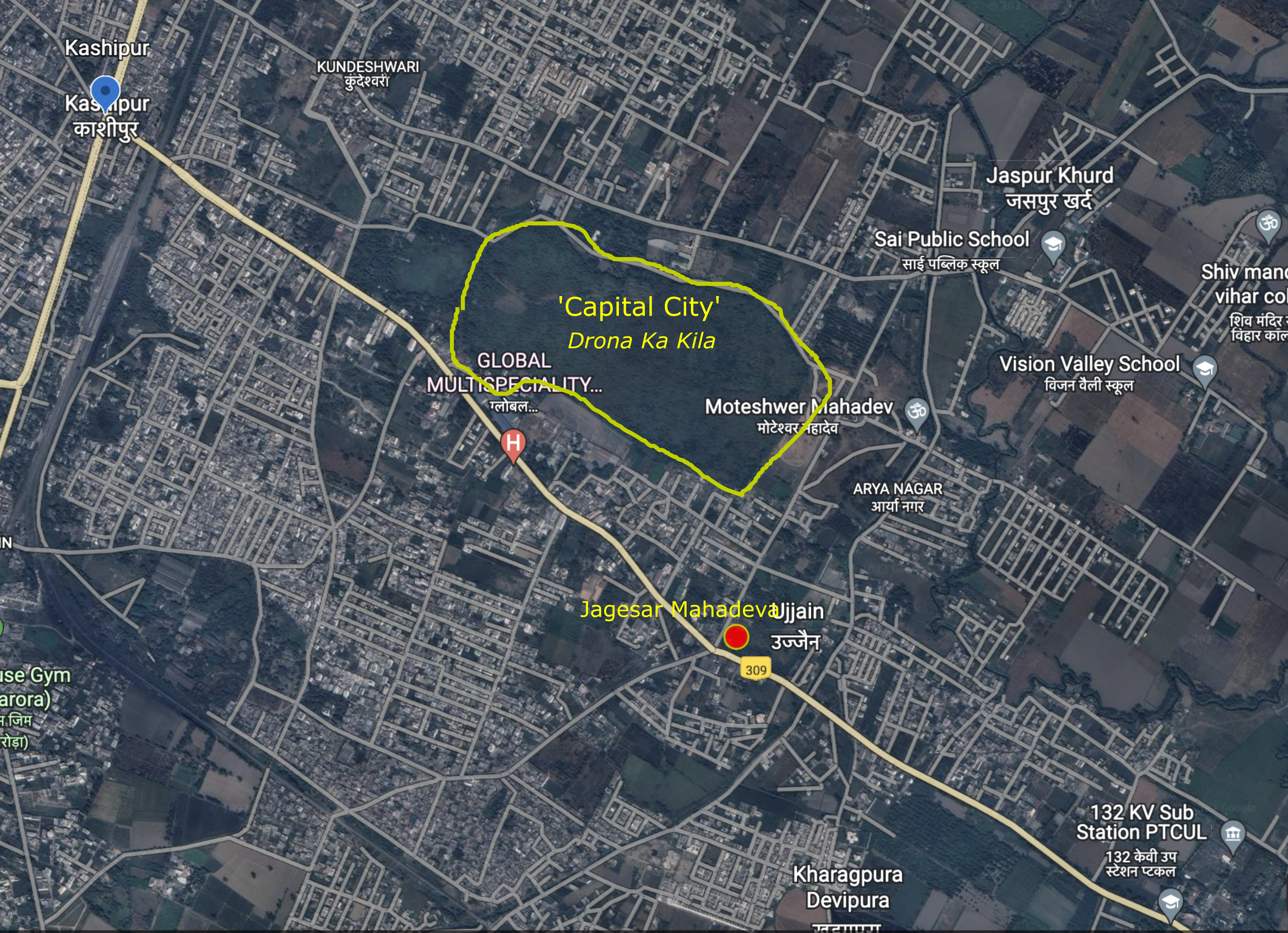 |
‘capital city’ and Jagesar Shrine plotted on Google Map. |
 |
Survey map of Kāshipur prepared by Alexander Cunningham. |
 |
With Ranjeet Negi in front of the Panchayātana complex. |
 |
Inside the ‘capital city’. |
 |
With Ranjeet and Shri Vikas Kumar Agnihotri. |
 |
With Dr P K Sagar. |
 |
The Jagesar Mahadeva Shrine. |
 |
| The Jagesar Mahādeva shrine is situated on an ancient mound. |
 |
Exposed ancient wall during the excavation in 2004-05, Jagesar mound. |
 |
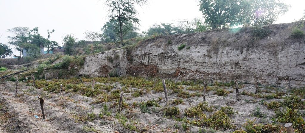
The eastern wall of the ‘capital city’. |
Ranjeet walked me to the Jagesar Mahādeva shrine complex (29° 11' 51'' N. 78° 58' 45'' E). Jagesar shrine is situated 600 mts SW of the ‘capital city’. The shrine was situated over a large archaeological mound, which is approximately an acre in size. Large bricks, brickbats and potsherds were scattered all over the Jagesar mound. Shri Vikas Kumar Agnihotri, chief priest of Pithadhishvar Temple and few other locals whom I met during my explorations in Kāshipur believe Jagesar Mahādev mound to be a Buddhist shrine, probably the Ashokan stūpa mentioned by Xuanzang. They hope its excavation and exposition will make Kāshipur a tourist/pilgrimage destination for the Buddhists. Shri Agnihotri told me that the site was excavated by ASI in 2004. According to Agnihotri ji, excavation of this mound in 2004 revealed it to be some Buddhist shrine. Agnihotri ji expressed his displeasure that the site was not completely exposed after some preliminary excavations in 2004-05.
Later, I had a telephonic conversation with Shri Dharmavir Sharma who had excavated the Jagesar Mahādeva mound in 2004-05. Shri Sharma, now a retired ASI official told that the Jagesar mound is a Brahmanical shrine from 6th CE and not a Buddhist stūpa, contrary to the common belief in Kāshipur. He told me how there were repeated requests from the state government to the ASI to find the ‘Ashokan stūpa of Goviṣāṇa’ mentioned by Xuanzang. ASI assigned Dr Sharma for this job. He followed the exploration reports of Cunningham for his research. Shri Sharma in his explorations noted that a large number of mounds noticed by Cunningham in Kāshipur had got destroyed by migrants who were settled in this vicinity after the partition of India in 1947. The new settlers, according to him, destroyed archaeological sites to convert them into agricultural land. The report of the excavation of Jagesar mound carried out by Shri Sharma is awaiting publication.
Jagesar mound, which was believed to be the stūpa noted by Xuanzang, instead turned out to be, a Brahmanical temple. So now the question is what happened to the Ashokan stūpa of Goviṣāṇa?
Cunningham in his report has mentioned a solid brick mound SW of Jagesar Mahādeva. Cunningham thought this mound could be of Buddhist origin. In the words of Cunningham;
“The only ruin which appeared to me to be of undoubted Buddhist origin was a solid brick mound 20 feet in height, to the south-west of Jagesar Mahadeva, and close to the small village of Kharagpur. The base of the mound is upwards of 200 feet in diameter. The solid brick-work at the top is still 60 feet thick; but as it is broken all round, its original diameter must have been much greater, probably not less than 80 feet. But even this larger diameter is too small for a stūpa of 200 feet in height of the hemispherical form of Asoka’s time; a stūpa of that early period, even when provided with both plinth and cupola, would not have exceeded 100 feet in height. Unless, therefore, we may suppose that there is a mistake of 100 feet in the text of Hwen Thsang, I feel quite unable to offer any identification of the Buddhist remains of Govisana as described by the Chinese pilgrim.”(Cunningham 2000: 251)
The ‘Buddhist’ mound documented by Cunningham is now lost. There are houses and market complexes all around the Jagesar shrine. Dr P K Sagar, a local resident of Jagesar Mahādeva, told me how all the houses in the neighbourhood including his house are made from large sized bricks unearthed/excavated from the mounds in the surrounding of Jagesar Mahādeva.
Unfortunately, the mound in question was lost even before it could be scientifically examined. But even if it survived, Cunningham was of the opinion that this mound SW of Jagesar was not big enough to represent the 200ft Ashokan stūpa of Xuanzang (Cunningham 2000: 251).
If we trust Cunningham’s identification of the ancient remains of Kāshipur to be the Goviṣāṇa of Xuanzang, it is plausible that the Buddhist monuments described by Xuanzang got vandalized long before Cunningham visited Kāshipur in 1862-63.
Even so, it is also conceivable that ‘Drona kā Kilā’ in Kāshipur may not be the correct identification of the ‘capital city’ of Goviṣāṇa. There are two major dissonances between the descriptions of the ‘capital city’ of Goviṣāṇa described by Xuanzang and the actual finds at ‘Drona kā Kilā’.
1. According to the translation of the accounts of Xuanzang by Li Rongxi, the capital city of Goviṣāṇa was surrounded by Lofty mountains that serve as impregnable barriers to the city (Rongxi 1996: 116). Translation of the same work by another sinologist Thomas Watters has mentioned the boundary of the capital city as a ‘natural stronghold’ (Watters 2004: 331). Broadly, ‘natural stronghold’ and ‘lofty mountains’ suggest the same, probably some hill or a mountain range that surrounded the ‘capital city’. The ‘Drona kā Kilā’ has a high fortified brick boundary which is certainly not a ‘natural’ fortification. The nearest ‘natural stronghold’, i.e. hills is the shiwālik range of Himalayas, which are situated more than 15 kms north of Kāshipur.
2. Xuanzang mentions the City of Goviṣāṇa to be 14-15 Li in circuit, which makes approximately 5 kms. However, the measurement of the fortification wall on Google Earth makes it to be only 2.6 kms. Cunningham has also noticed this discrepancy in the perimeter of City of Goviṣāṇa, mentioned by Xuanzang (Cunningham 2000: 253).
In his survey of this region, Cunningham noted Kāshipur to be the only place of any antiquity in this direction mentioned by Xuanzang (Cunningham 1871: 357). According to Cunningham, Kāshipur also fits well with respect to Ahichhatra, the next place on the route of Xuanzang. We have quite a few examples where identifications offered by Cunningham were found to be incorrect by the scholars after him. For example, the identification of Mokson as Lumbini and Nagar as the City of Kapilavastu (Cunningham 1871), both the identifications offered by Cunningham in the 1860s were corrected in 1890s. The primary reasons behind many of the incorrect identifications offered by Cunningham were the rudimentary maps available in his times. Awareness and mapping of archaeological features was in its infancy, in the mid 19th CE.
And last but not the least; we cannot be very certain if Xuanzang actually visited Goviṣāṇa. Biography (Beal 1914) and Travels (Rongxi 1996), the two separate accounts of Xuanzang have different descriptions of how Xuanzang travelled onwards from Matipura. As per the Travels, from Matipura Xuanzang travelled to Goviṣāṇa and from Goviṣāṇa he travelled to Ahicchattra (Rongxi 1996: 116). However, according to the Biography, from Matipura, Xuanzang travelled to Brāhmanpura and from Brāhmapura to Ahicchatra (Beal 1914: 81). There is no mention of his visit to Goviṣāṇa between Matipur and Ahicchatra in Biography as mentioned in Travels. I think, this inconsistency between Biography and Travels is because Xuanzang may not have actually visited Goviṣāṇa and may have collected information about Goviṣāṇa at Matipura or Ahicchatra.
I think, there is enough evidence to re-examine the identification of Kāshipur as the ancient Goviṣāṇa. I believe that more exploration and scientific study is required in this region to locate the ancient Goviṣāṇa and the Buddhist monuments mentioned by Xuanzang in Goviṣāṇa.
Story chronicled by Surinder M Talwar.
Bibliography:
Beal, S.; 1914, The life of Hiuen-Tsiang by Shaman Hwui Li by Kegan Paul. London: Trench Trubner and Co
Cunningham, A; 2000, Archaeological Survey of India Four Reports Made During the Years 1862-63-64-65, Vol-I,
Published by ASI, GOI, 2000, (First Published in 1871).
Cunningham, A.1871. The Ancient Geography of India - I: The Buddhist Period. London: Trubner and Co.
Rongxi, Li; 1996, The Great Tang Dynasty Record of the Western Regions, BDK America, Inc.
Watters, Thomas; 2004, On Yuan Chwang’s Travels in India, (Edited by T. W. Rhys Davids and S.W. Bushell), Reprinted in LPP 2004, Low Price Publications, Delhi.
Website of Archaeological Survey of India, Dehradun Circle, Uttarakhand
https://www.asidehraduncircle.in/excavation.html