 |
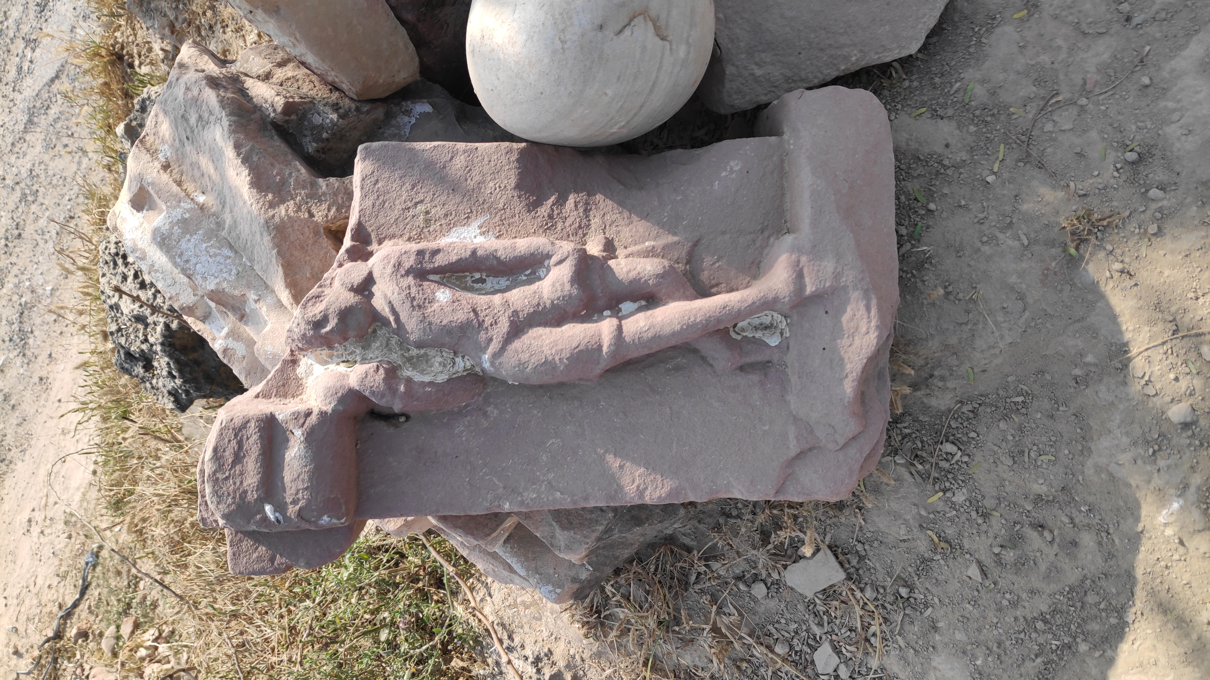
Holding the broken sandstone image of Buddha. Chintāmani. |
Life (Beal 1914) and Travels (Rongxi 1996), the two accounts of Xuanzang’s journey, have mentioned two 200 ft Ashokan stūpas in the immediate neighborhood of Kanyākubja (now Kannauj), to mark the place where the Buddha gave sermons. The first Ashokan stūpa mentioned by Xuanzang was situated north-west of the City. The Ashokan stūpa to mark where Buddha preached Dharma was situated north of the river Ganges (Rongxi 1996: 130). Besides this Ashokan stūpa Xuanzang saw a small stūpa containing hair and nail relics of Buddha. Close to the Ashoka stūpa were three monasteries built in one enclosure, with separate entrances. A temple in this monastic complex had the tooth relic of the Buddha, stored in a precious casket. At each side, and in front of the monasteries there was a temple more than one hundred feet high, built with brick, on stone foundations. In front of each of the two temples, there existed a small monastery. At a short distance south-east of the monasteries was a colossal 200 ft temple made out of brick, on stone foundation, housing a standing statue of the Buddha of over thirty feet in height. Xuanzang also noticed several thousand families of monastic servitors living nearby.
By any estimate this Buddhist complex of three monasteries, a 200 ft Ashoka stūpa, numerous temples and hundreds of monastics and their servitors living, should be large and spread in a large area. Cunningham expressed his inability to identify any Buddhist remains in Kannauj mentioned by Xuanzang. Cunningham offered few conjectures but expressed his inability to find anything of importance in those places (Cunningham 2000: 284, 291).
On my foot journey, I arrived at Kannauj on 17th October 22. On way to Kannauj from Gurusahaiganj I was joined by Shri Ram Babu Shakya, Shri Shiv Pratap Singh, Shri Ramendra Kumar Shakya, Shri Aditya Vikram Singh Shakya, Shri Rahul Pratap Singh Shakya, Shri Narayan Kushwaha and Shri Gautam Shakya. All of them are heritage volunteers who came from Chhibramau to help me in my Kannauj explorations. All of us first went to the Govardhani Māi temple. Govardhani Māi (27° 04' 47'' N. 79° 51' 58'' E) is an extremely popular shrine among the locals. The temple is situated on a very huge mound. At first glance the mound looks like the remains of a huge stūpa. Govardhani Māi temple has many ancient Brahmanical sculptures but the most prominent sculpture at the site is a Jaina image from the medieval period. A broken brick that I found measured 3in X 10.5in X 14in (approx.).
 |
Map 1. Ancient sites and river beds in Kannauj plotted on Google Map. |
 |
Map 2. Dahelpur, Chintāmani, Ismailpur and Kali Nadi plotted on Google Map. |
 |
Map 3. Ancient mounds in Dahelpur. |
 |
Govardhani Māi Shrine. |
 |
A Jaina image at Govardhani Māi Shrine. |
 |
Ancient bricks in a vandalised mound. Govardhani Māi Shrine. |
 |
| With the group of heritage activists from Chibaramau. |
This mound could date from a very early period. But, the Govardhani Māi site may not be the Ashokan stūpa mentioned by Xuanzang for a number of reasons; firstly, it is situated approximately 6 kms north-west of Kannauj. Xuanzang has not given the distance of the site, but I think the site mentioned by Xuanzang should be 1-2 kms from the city. Practically, a distance of 1-2 kms is convenient for the followers to visit Buddha and also convenient for the Buddha and the Sangha to walk for collecting their daily alms to the nearby habitations. Secondly, the archaeological site is not big enough to match the descriptions of Xuanzang. We did some explorations in the neighborhood of Govardhani shrine and inquired with the locals. There were not many mounds to complement the description of Xuanzang. And thirdly, the ‘Ashokan stūpa’ in question was situated on the north bank of the Ganges. Local people informed me that the Ganges presently flows more than 2 kms north of the site and that there are no ancient river beds anywhere near the Govardhani temple.
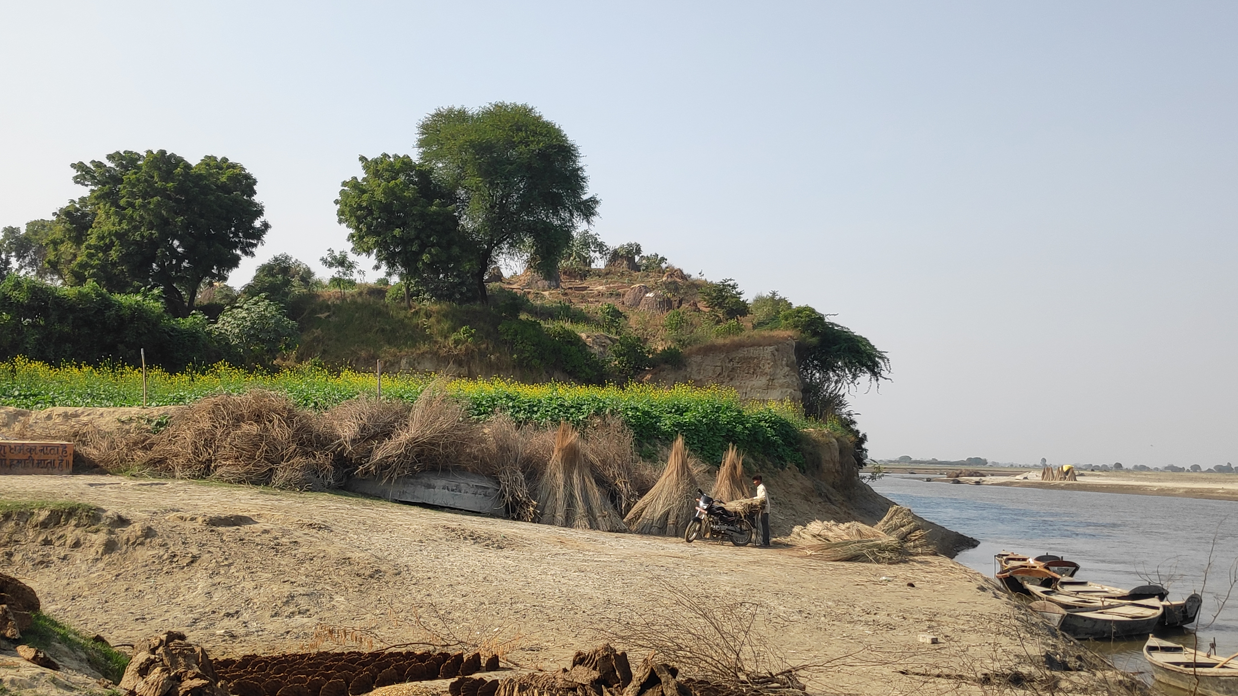
After arriving in Kannauj city we went straight to another very popular shrine called Chintāmani Temple. The previous night, I met a school teacher Shri Sushil Shakya in Gursahaiganj. Sushil ji had noticed huge mounds in the neighborhood of Chintāmani shrine in Kannauj. He emphasized that I should visit Chintāmani temple and its surrounding. As I was entering the Chintāmani village, my eyes lit up with surprise. I noticed a broken sandstone image of the standing Buddha lying by the roadside. Villagers told me the find spot of the Buddha and other images lying in Chintāmani is Dhaelpur, a village less than one kilometre further north. As I approached Dhaelpur I noticed a very huge imposing mound approximately 50 ft high from the road on which I was walking. The mound was multitier, covered by small-small green patches of farms. It was obvious; that the ancient mound was being used for agriculture. Here, I met a curious elderly person, Shri Ram Awatar ji who after some discussion volunteered to take us around. The mound (27° 05' 00'' N. 79° 54' 50'' E) was locally referred to as ‘Gaḍhi’, meaning a fortress. We climbed-up the mound from its west side. The mound was flat on the top. There was a sculpture collective that had broken stone sculptures and temple panels. From the top of the mound, I noticed a river stream touching the Gaḍhi mound on the south side. Ram Awatar ji informed us that once the Ganges flowed from here and the stream sighted by us was of river Gangā (the Ganges).
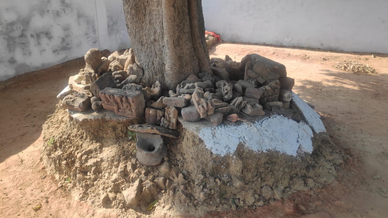
From Google Earth, I found that the stream was actually Kāli Nadi, a rivulet that originates from foothills of Himalayas. It follows approximately 500 kms of winding path in the plains between the rivers Gangā and Yamunā. On its way to Kannauj, it also touches the Buddhist sites of Atranji Kherā and Sankissa. Kāli Nadi moving past Dahelpur finally confluences with the Ganges just 3 kms east of Dhaelpur. From the top of the Gaḍhi mound I noticed another mound on its north. A village road divided the two mounds. The second mound according to Shri Awatar ji was called ‘Rājā Basuk’. Rājā Basuk was not as tall as Gaḍhi, but was spread over large area. Maybe, it extended more than 300 mts further north. Unlike the Gaḍhi mound which was mostly free of encroachment, the Rājā Basuk mound was totally occupied by houses. Dhaelpur village was settled over it. Ancient bricks were all over the mounds. Neighboring fields were full of potshards and brickbats. I noticed a big vertical cut on the south-eastern face of Gaḍhi mound. This large cut had revealed a cross section of Gaḍhi where ancient bricks could be seen bulging. I noticed seven sculpture collectives in different corners of the Dhaelpur. All the sculptures were Brahmanical. They were broken and disfigured. I think, I found a disfigured head of Buddha in one of the sculpture collectives in Dhaelpur. A brick that I measured near a field at Dahelpur was 1.7in X 7in X 11in.
 |
With Sushil Shakya ji and my host Veerpal Kushwaha ji. Gurusahaiganj. |
 |
Gaḍhi mound from south side. Dahelpur. |
 |
A broken sandstone image of Buddha in a village collective. Chintāmani |
 |
Kāli Nadi from the top of Gaḍhi mound. Dahelpur. |
 |
Sculpture collective on the Gaḍhi mound. Dahelpur. |
 |
A mound north of Gaḍhi mound. Dahelpur. |
 |
Rājā Basuk mound. Dahelpur. |
 |
| Rājā Basuk mound. Dahelpur. |
 |
The vandalisation of the Gaḍhi mound revealing ancient bricks. Dahelpur.
|
Some Sculptures found in Dahelpur
 |
| One of the sculpture collectives with broken images. Dahelpur. |
 |
| Disfigured Buddha Head ? (Dahelpur) |
 |
| With Shri Ram Awatar ji. Dahelpur. |
Xuanzang further mentioned two big and beautiful Brahmanical shrines situated ‘not far to the south’ of the stone temple of standing Buddha image. The first temple was of God Sūrya and another one further south, was dedicated to God Maheśvara.
Approximately 1.5 km south of Gaḍhi mound, I noticed two big mounds in a small village called Ismailpur Nooruddinpur. The first mound called Meenā Bāzār (27° 04' 17'' N. 79° 55' 01'' E), had a dilapidated muslim shrine made from Lākhori bricks on its top. The mound proper was around half an acre big but its immediate surroundings were strewn with ancient brickbats spread in a large area. The second mound called Chandan pir (27° 04' 15'' N. 79° 55' 04'' E) also contained a muslim shrine, which was made by reusing sandstone panels of ancient Brahmanical shrine. Broken sculptures and parts of the temple were scattered inside and outside the Chandan Pir. The shrine is situated on the northern end of the 0.4 Acre big mound. Shri Sarvesh ji, who has his house on the mound, informed me that the shrine has very few and occasional visitors. One brick that I measured at Chandan pir was 2in X 8.1in X 14.5 in. The Meenā Bāzār and Chandan Pir mounds were 100mts apart from each other.
Based on my findings, I am convinced that Dhaelpur is the site of the Buddhist complex mentioned by Xuanzang. Firstly, Dhaelpur is situated approximately 2 kms North-North-West of the NW edge of the ancient Kannauj city, which is the ideal distance for a monastery from a city or village. Secondly, it is situated on the northern bank of the river (Kāli Nadi) as mentioned by Xuanzang. Kāli Nadi is a tributary of Ganges and confluences with the Ganges at the eastern edge of village Dahelpur. Thirdly, Gaḍhi and Rājā Basuk mound and the mounds in their surroundings are spread in more than 20 acres of land, and thus match up with the descriptions of Xuanzang. Fourthly, the presence of the 6-7th CE, broken sandstone image of the Buddha suggests a Buddhist connection to the place. Excavation of mounds in Dahelpur may yield more Buddhist remains. It is also important to note that the remains of Brahmanical temple in Ismailpur Nooruddinpur, situated south of Dhaelpur village, match the descriptions of Xuanzang. Dahelpur, Chintāmani and its surroundings need scientific study from competent professionals to find the complete truth.
 |
| Meenā Bāzār mound. A muslim shrine on the top. Ismailpur. |
 |
| With villagers at Meenā Bāzār mound. |
 |
| A Brahamanical artefacts at Chandan Pir Shrine. Ismailpur. |
 |
| Chandan Pir Shrine. Ismailpur. |
 |
| A Brahamanical artefacts at the Chandan Pir Shrine. Ismailpur. |
 |
| Shri Sarvesh ji showing an ancient motif panel at the Chandan Pir. Ismailpur. |
 |
| Villagers showing the Brahamanical past of the Chandan Pir. Ismailpur. |
 |
| An ancient brick from Chandan Pir mound. Ismailpur. |
 |
| Encroachment around the Meenā Bāzār mound |
 |
| Chintāmani Shrine.
|
The second Ashokan stūpa to mark the presence of the Buddha mentioned by Xuanzang was located 6-7 Li SE of Kannauj City. It was here that the Buddha had delivered the ‘doctrine of impermanence.’ Beside it is a site where the four past Buddhas used to sit and walk up and down. Near it was another small stūpa containing hair and nail relics of the Buddha. The stūpa according to Xuanzang was propitious. Anyone circumambulating the stūpa with a pious mind would get cured of illness. Faxian has also mentioned about the Ashokan stūpa to mark the place where the Buddha had delivered the ‘doctrine of impermanence’ (Legge 1886). Faxian places the stūpa 6-7 Li West of the City and on the northern bank of the river. Obviously, both the pilgrims are describing the same Ashokan stūpa where the Buddha delivered his talk on impermanence, but, there is inconsistency between the descriptions of both the pilgrims.
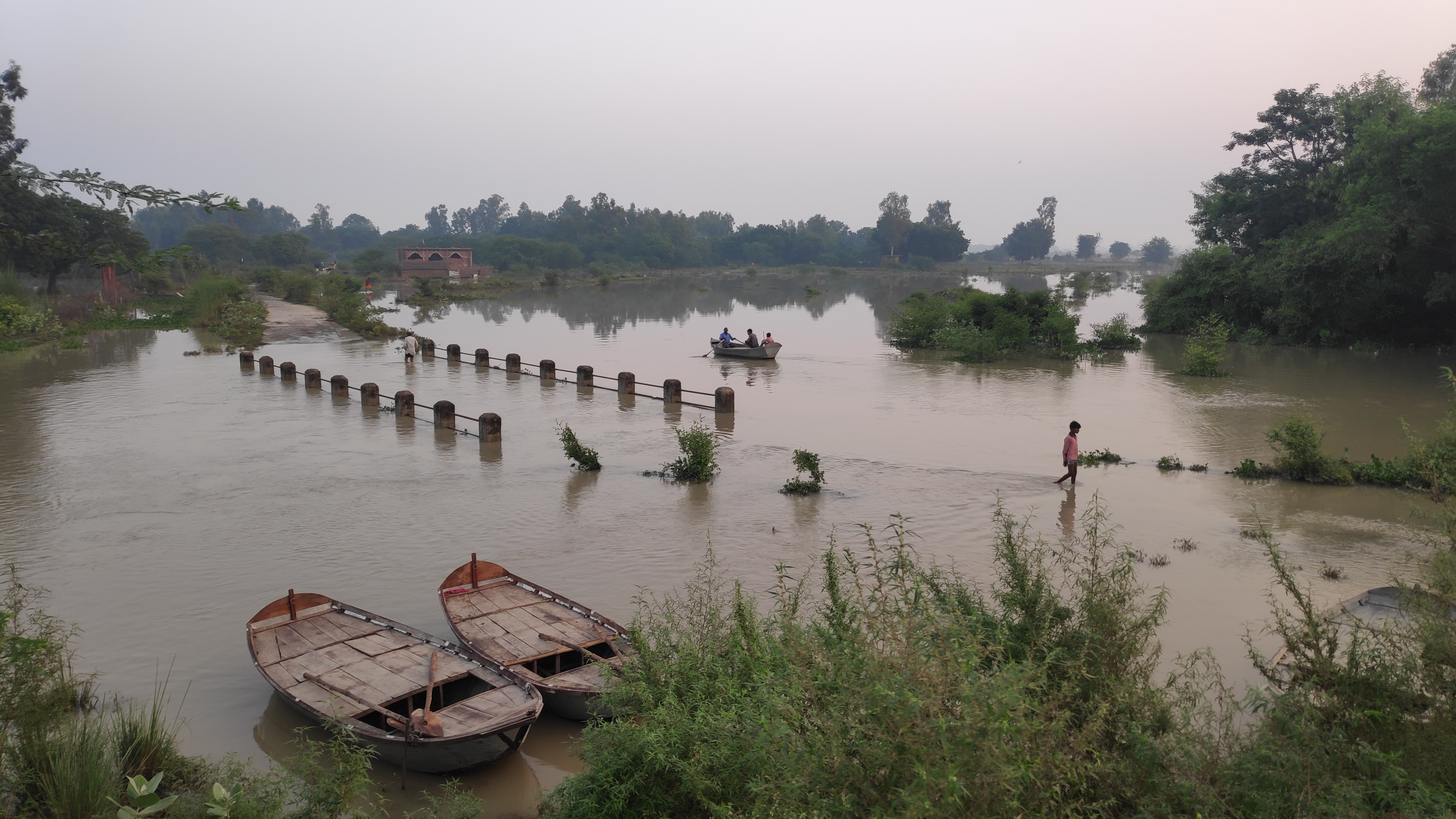
Next, I decided to walk from Dargha Hazrat, the north-west border of the ancient city to Mehndi Ghāt, situated little beyond the south-east border of the ancient city. This is approximately 10 km long road that runs parallel and adjacent to the remains of the ancient Kannauj. The 10 ft wide road keeps Kannauj on its south side and the Ganges on its north. All along this road, I noticed a continuous mound with a 15-20 ft high wall made up of crumbling bricks and earth. This continuous mound looked like the remains of a fortification wall. This mound runs continuously from Dargah Hazrat in the NW to Abādi Rājgir in the SE. Xuanzang mentioned the City to be 20 Li long (Rongxi 1996: 121), which comes to approximately 6 to 7 Kms. Abādi Rājgir is situated 6.5 kms as the crow flies SE of Dargah Hazrat. It seems Abādi Rājgir could be the eastern limit of the ancient city of Kannauj. I also noticed that this continuous mound from Dargah Hazrat to Rājgir has prominent spikes in the villages of Salempur and Deokali, where the mound rises up to 30-45ft.
Cunningham had proposed Kishen Kali Burj and Mahallā of Lāla Misr situated to the south-east of the Killah Mound as the probable site of Ashoka stūpa mentioned by Xuanzang. The killah mound is a part of the ancient city of Kannauj, over which the modern city of Kannauj is settled (Cunningham 2000: 284). Both the places identified by Cunningham are situated SE of killah mound but still they were inside the ancient city of Kannauj. The Ashokan stūpa according to Xuanzang was outside the ancient city of Kannauj. Hence, Kishen Kali Burj and Mahallā of Lāla Misr proposed by Cunningham do not qualify the descriptions of location of the Ashokan stūpa mentioned by Xuanzang.
Around 1.5 kms further east of Abādi Rājgir I noticed big mounds in village Gumtiyā (27° 01' 10'' N. 79° 58' 22'' E). This village was partially settled over a mound. These mounds were situated adjacent to the Ganges. The northern face of the mound was washed off by the Ganges. The exposed cross section of the mound revealed a few layers of bricks. The exposed bricks were out of my reach, but I noticed the bricks were big sized and could be very ancient. Xuanzang has placed the stūpa to be 6-7Li SE of the city. This comes around 2-3 kms. If Abādi Rājgir is indeed the eastern limit of the ancient Kannauj city then the Gumtiyā village is the potential site of the 2nd Ashokan stūpa mentioned by Xuanzang.
 |
| View of River Ganges from the Gumtiyā mound. |
 |
| Ancient bricks all over the Gumtiyā mound. |
 |
| The Gumtiyā mound cut by the Ganges exposing ancient bricks. |
 |
| Gumtiyā Mound by the Ganges. |
 |
| Sculpture collective called Gumtiyā Tikhā. |
 |
| A sculpture in the sculpture collective called Gumtiyā Tikhā.
|
 |
| A sculpture in the sculpture collective called Gumtiyā Tikhā. |
|
 |
Shri Vishram Singh, Gumtiyā Tikhā.
|
 |
| A roadside sculpture shed near between Gumtiyā and Mehndi Ghāt. |
 |
| A roadside sculpture shed near between Gumtiyā and Mehndi Ghāt. |
 |
A roadside sculpture shed near between Gumtiyā and Mehndi Ghāt.
|
 |
| Overflowing river due to heavy rains on 8-10th October. |
 |
| Morning time. somewhere near Kannauj. |
It is surprising, Kannauj was a flourishing Buddhist center at the time of visit of Faxian (5th CE) and Xuanzang (7th CE), yet, there are almost negligible Buddhist artifacts discovered from Kannauj. Government Archaeological Museum, Kannauj has no Buddhist sculptures in its display. Numerous sculpture collectives that I encountered during my exploration in Kannauj and its surroundings had only Jaina and Brahmanical images from the medieval period except for the lone 6-7th CE Buddha image that I discovered at Chintāmani.
Most likely, after Harshavardhana (590 to 647 CE), the rulers, patrons and the people of Kannauj shifted their allegiance from Buddhism to other faiths like Brahmanism and Jainism. Xuanzang in his visit to Kanyākubja has documented how ‘heretics’ attempted to kill King Harshavardhana because he was giving patronage to the Buddhists (Rongxi 1996: 130).
Dr Jalaj Kumar Tiwary, a senior archaeologist from the Archaeological Survey of India, based on his study of images from the medieval period found in Nālandā and its surroundings has argued how people in Nālandā in 11th CE onwards gradually shifted their allegiance towards Brahmanism (Tiwary 2021). I think something similar might have happened here at Kannauj after the reign of Harshavardhana (606 to 647 CE). A detailed archaeological study of ancient remains in Chintāmani, Dhaelpur, Gumtiyā and other sites in Kannauj may reveal the complete truth about the Buddhist remains mentioned by Xuanzang in Kanyākubja.
Story chronicled by Surinder M Talwar.
Bibliography:
Beal, S.; 1914, The life of Hiuen-Tsiang by Shaman Hwui Li by Kegan Paul. London: Trench Trubner and Co.
Cunningham, A.; 2000, Archaeological Survey of India Four Reports Made During the Years 1862-63-64-65, Vol-I, Published by ASI, GOI, 2000, (First Published in 1871).
Cunningham, A.; 1871, The Ancient Geography of India - I: The Buddhist Period. London: Trubner and Co.
Rongxi, Li; 1996, The Great Tang Dynasty Record of the Western Regions. BDK America, Inc.
Tiwari, Jalaj Kumar.; 2021, An Interesting Bifacial Stone Slab from Baragaon, District Nalanda, Bihar Province. Varanasi: Arnava Volume X No.1.
Watters, Thomas; 2004, On Yuan Chwang’s Travels in India, (Edited by T. W. Rhys Davids and S.W. Bushell), Reprinted in LPP 2004, Low Price Publications, Delhi.
Legge, James; 1886, Records of the Buddhistic Kingdoms by Chinese monk Fa-Hien.
Buddha Dharma Education Association Inc.
Downloaded from http://www.buddhanet.net/pdf_file/rbddh10.pdf


1 comment:
Nice
रिसर्च
Post a Comment